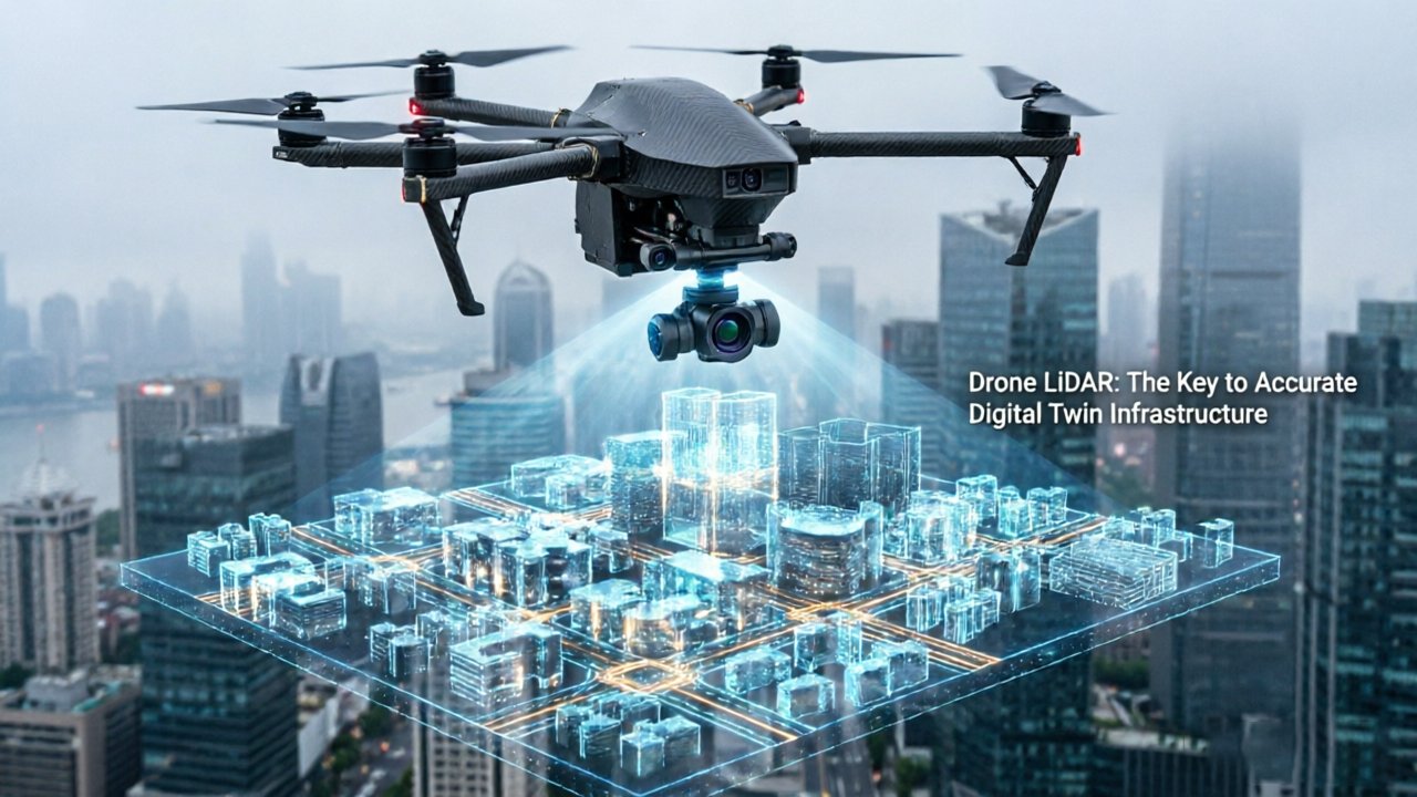
Smart infrastructure can’t be built on flat maps — it demands geometric truth at centimeter precision. The gap between a conventional aerial photograph and a genuine digital twin isn’t a matter of resolution; it’s a matter of dimension. Where imagery captures surfaces as pixels, LiDAR captures them as measured geometry — every wall angle, every drainage gradient, every structural overhang assigned a precise coordinate in three-dimensional space.
That distinction matters enormously once cities start asking serious operational questions. Drone LiDAR 3D city modeling moves urban data collection out of the cartographic era and into the simulation era. Rather than asking “what does this block look like?”, planners can ask “how will stormwater move across these surfaces during a 100-year rain event?” or “where will pedestrian bottlenecks form when this interchange closes?” Those questions require geometry, not imagery.
As Geospatial World notes, “digital twins powered by LiDAR are no longer just 3D maps; they are living models that allow for real-time simulation of urban heat islands, flood risks, and traffic flow.” That phrase — living models — captures exactly what separates genuine infrastructure intelligence from a static survey deliverable.
The hardware requirements for this level of urban capture are non-trivial. Systems with high vertical channel counts are essential for resolving the dense, overlapping geometries of urban canyons where buildings, canopies, and infrastructure compete for the same scan window. High-density capture — sensors operating at hundreds of thousands of points per second — isn’t a spec-sheet luxury; it’s the baseline for structural fidelity in complex environments.
- Geometric accuracy: Centimeter-level precision enables credible physics-based simulation
- Living model capability: Continuous data feeds allow flood, heat, and traffic models to update dynamically
- Point density requirements: Urban environments demand sensors capable of resolving fine structural detail at scale
The path from raw point cloud to actionable urban intelligence, however, runs through a highly automated extraction pipeline — and that’s where the real technical complexity begins.
Automating the Pipeline: How to Extract 3D Buildings from LiDAR Data
The ability to extract 3D buildings from LiDAR data automatically — rather than manually — is what separates a scalable smart city workflow from an expensive, one-off survey project.
Automated feature extraction begins with classification. Raw point clouds return from a drone flight as an undifferentiated mass of millions of data points. Specialized processing software segments those points by return intensity, flight geometry, and elevation variance to identify ground, vegetation, and — critically — building structures. Facade planes, rooftop edges, and wall corners emerge not from human interpretation, but from algorithmic pattern recognition running across the full dataset.
Noise filtering is where urban environments test the pipeline hardest. Dense cities introduce a continuous stream of transient objects — moving vehicles, pedestrians, tree canopies swaying in wind — that embed false geometry into the raw capture. Processing pipelines apply statistical outlier removal and temporal filtering to strip these artifacts before they corrupt structural models. Without this step, a building’s ground-floor facade can appear fragmented or offset, introducing errors that cascade into every downstream analysis.
Once clean, the classified point cloud undergoes vectorization — the conversion of discrete 3D point clusters into continuous geometric surfaces. Rooftop polygons, wall planes, and window apertures become parametric vector objects that can be queried, measured, and modified. This is the moment raw sensor data becomes actionable geometry. Understanding how LiDAR differs from camera-based capture helps clarify why this conversion is far more reliable than photogrammetric mesh reconstruction, particularly on reflective or shadowed surfaces.
Capture density is the non-negotiable foundation of structural fidelity. According to LiDAR Magazine, drone LiDAR systems can capture up to 600,000 points per second, producing point clouds dense enough to resolve individual facade details at centimeter scale. Sparse datasets simply cannot support accurate vectorization of complex architectural geometry.
That geometric precision, once embedded in a vector model, sets the stage for something even more powerful — direct integration into the BIM workflows reshaping how engineers design, build, and maintain smart infrastructure.
The Scan-to-BIM Revolution in Smart Infrastructure
LiDAR point clouds become truly transformative when they feed directly into the design and engineering software that smart infrastructure projects run on.
Once an automated extraction pipeline produces a clean, classified point cloud — as covered in the previous section — the natural next step is getting that data into a format engineers and planners can act on. That’s exactly where Scan-to-BIM automation changes everything. Rather than dispatching surveyors to manually measure existing structures and transcribe those figures into design models, teams can import LiDAR data directly into platforms like Revit and AutoCAD, generating parametric 3D models that reflect reality with centimeter-level accuracy.
📌 What is Scan-to-BIM?Scan-to-BIM is the process of converting raw LiDAR point cloud data into intelligent, parametric Building Information Models. Instead of building models from manual measurements, engineers import the point cloud directly, letting the software detect walls, floors, structural elements, and MEP systems automatically.
Manual measurement error has long been a silent cost in urban planning. A misread dimension or a transcription mistake at the survey stage can cascade into expensive design revisions later. By grounding BIM models directly in raw scan data, that error source is effectively removed from the workflow. According to Autodesk’s BIM solutions research, integrating LiDAR point clouds into BIM workflows reduces overall modeling time by up to 50% compared to traditional surveying methods — a gain that compounds across large-scale city projects.
Digital twin fidelity is the other critical benefit. A digital twin is only as reliable as its ability to reflect real-world changes — structural aging, retrofits, new additions. Periodic LiDAR rescans fed through the same Scan-to-BIM pipeline keep the model current, ensuring decisions about load capacity, utility upgrades, or emergency response are grounded in the building’s actual present-day geometry, not an outdated baseline.
Of course, BIM-ready accuracy at the building level is just one part of the picture. Smart infrastructure also demands equally precise data about the ground beneath it — particularly in areas where dense tree cover complicates surface capture entirely.
Penetrating the Canopy: LiDAR’s Hidden Advantage in Urban Expansion
Drone LiDAR’s ability to see through vegetation — not just above it — is one of the most underappreciated capabilities driving accurate digital twin infrastructure at urban boundaries.
Multi-echo capability is the core mechanism. When a laser pulse hits a tree canopy, it doesn’t stop. A portion of the signal threads through gaps in the foliage and strikes the ground below, returning multiple echoes from a single pulse. The sensor records all of them — the top of the canopy, intermediate branches, and the bare earth underneath. This multi-return processing enables surveyors to strip away vegetation returns in post-processing and isolate a true ground surface with centimeter-level accuracy.
Photogrammetry simply cannot replicate this. Optical cameras capture only what they can see. In wooded urban fringes — the transitional zones where cities expand into forested or semi-rural land — dense canopy cover creates an opaque barrier for image-based mapping. The result is a surface model that represents treetops, not terrain. As GIM International notes, drone LiDAR penetrates dense vegetation and canopy cover to reveal true ground topography through a Digital Terrain Model (DTM), which is impossible with standard photogrammetry.
That distinction matters enormously for foundational engineering. A DTM built from photogrammetry in a wooded area isn’t just imprecise — it’s misleading. Drainage planners working from inflated surface elevations will miscalculate runoff paths, undersize culverts, and potentially expose new developments to flood risk. LiDAR-derived DTMs give civil engineers the reliable slope and basin data they need before a single foundation is poured.
The environmental challenges LiDAR routinely resolves in urban expansion scenarios include:
- Dense tree canopy obscuring true ground elevation
- Tall grass and scrubland masking shallow depressions and drainage channels
- Mixed vegetation density creating inconsistent surface artifacts in image-based models
- Seasonal leaf cover that renders repeat photogrammetry surveys unreliable
For new development projects, this accuracy isn’t a luxury — it’s a prerequisite. Getting the terrain wrong at the survey stage cascades into costly redesigns downstream. As smart city projects push further into complex terrain, the hardware powering these surveys becomes just as critical as the data it produces — which raises an important question about how that hardware reaches the teams who need it most.

Scaling the Digital Twin: The Case for Factory-Direct Hardware
Procurement bottlenecks remain one of the most overlooked barriers to deploying high-density point cloud urban planning programs at scale — and the hardware supply chain is where many smart city initiatives quietly stall.
Traditional LiDAR distribution inflates costs and slows timelines. Multi-tier distribution channels — manufacturer to regional distributor to reseller to end customer — routinely add 20–40% to unit costs while introducing lead times that stretch from weeks into months. For municipal infrastructure programs operating on fixed budget cycles, that kind of delay doesn’t just affect a single project; it derails entire deployment roadmaps.
Here’s why the factory-direct model changes the equation for engineers and procurement teams:
- Cost efficiency at scale. Eliminating intermediaries removes compounding margin markups, making it realistic to deploy sensor arrays across multiple infrastructure sites rather than piloting a single location. The savings often fund the sensor redundancy that autonomous fleets require.
- Triple-certified hardware assurance. Municipal contracts increasingly mandate CE, FCC, and RoHS certification for any electronics integrated into public infrastructure. Sourcing direct from a manufacturer with documented triple certification removes the compliance ambiguity that delays project sign-off — a critical consideration when industrial-grade durability standards are written into procurement specs.
- 24-hour global support continuity. Autonomous drone fleets don’t operate on a 9-to-5 schedule, and neither should hardware support. Direct manufacturer relationships with round-the-clock technical coverage mean firmware issues, sensor calibration flags, or integration errors get resolved before they cascade into costly downtime.
The ROI case is straightforward: every layer of distribution removed accelerates the path from purchase order to operational digital twin. For city planners under pressure to demonstrate infrastructure modernization, that speed-to-deployment advantage translates directly into measurable outcomes — precisely the kind of data that feeds the simulation environments covered in the next section.
Real-Time Simulation: Testing Urban Resilience
High-fidelity digital twins don’t just mirror a city — they let planners stress-test it before a single shovel breaks ground or a single storm rolls in.
Geometrically precise LiDAR models give city officials the power to run ‘what-if’ scenarios that test smart infrastructure against environmental and operational change — a capability confirmed by Geospatial World research on 4D spatial-temporal infrastructure frameworks. That predictive power plays out across four distinct planning challenges.
Flood risk modeling is where centimeter-accurate elevation data earns its keep. Even a 10–15 cm error in a traditional survey can misclassify an entire neighborhood’s drainage profile. With drone LiDAR-derived terrain models, hydrological simulations can trace water movement through streets, underpasses, and green corridors with a level of precision that coarse photogrammetry simply can’t match. Planners can identify vulnerable zones and model the effect of proposed interventions — retention basins, elevated road sections — before committing capital.
Traffic flow modeling benefits equally from geometric accuracy. A 3D environment that faithfully represents lane widths, intersection geometries, and building setbacks allows transportation engineers to simulate congestion patterns, emergency vehicle routing, and pedestrian conflict points under varying load conditions. The model becomes a testbed, not just a reference map.
Urban heat island analysis adds another dimension. Building density models derived from point clouds allow planners to identify thermal hotspots, test the cooling effect of proposed green roofs or tree canopy additions, and prioritize interventions in the neighborhoods that need them most.
Finally, predictive maintenance ties it all together. Infrastructure assets — bridges, retaining walls, utility corridors — can be monitored against their baseline digital twin states, flagging anomalous deformation or degradation before failure occurs. For teams managing real-time sensing across complex environments, this closes the loop between capture, model, and action.
That loop, however, only functions when the hardware feeding the twin speaks the same language as the software processing it — which is exactly where the next piece of the puzzle comes in.
Integrating the Ecosystem: From Sensors to Software
Turning raw drone LiDAR data into a functioning digital twin demands a tightly integrated software stack — one where every layer, from sensor firmware to final BIM export, speaks the same language.
Hardware-software interoperability is the first bottleneck most programs hit. Drone-mounted LiDAR sensors generate proprietary data streams that must sync with IMU and GNSS outputs before a single usable point exists. Without validated driver support and calibration profiles between sensor and flight controller, even a 600,000-point-per-second scanner produces misaligned, unusable captures. Choosing sensors with open SDK access and documented API layers — options increasingly available through direct-source hardware procurement — dramatically reduces integration friction at scale.
Processing pipeline is where raw captures become assets. A standard workflow moves through four stages:
- Georeferencing — fusing LiDAR returns with GNSS/IMU trajectory data to assign absolute coordinates
- Point cloud filtering — noise removal, ground classification, and outlier rejection
- Feature extraction — identifying structural elements like facades, road surfaces, and utility corridors
- BIM/GIS export — converting classified data into IFC, Shapefile, or CityGML formats compatible with downstream planning tools
Understanding the role of 2D versus 3D sensors matters here. 2D LiDAR handles planar cross-sections efficiently — useful for corridor mapping and road-level detection. 3D sensors, by contrast, capture full volumetric geometry essential for structural digital twins. Hybrid urban programs increasingly deploy both: 2D sensors for ground-level mobile passes and 3D drone-mounted units for aerial sweeps, with software merging the datasets into a unified spatial model. The digital twin bridge workflow demonstrates exactly how these layers fuse into a single coherent output.
Data longevity is the often-ignored dimension of the software stack. Research published in a 4D spatial-temporal infrastructure study emphasizes that infrastructure digital twins must remain accurate across decades — not just at capture time. That requires version-controlled point cloud archives, standardized metadata schemas, and change-detection algorithms that flag structural drift between survey cycles. Engineers evaluating platforms today should treat long-term data governance as a core technical requirement, not an afterthought.
With the full ecosystem mapped — from sensor to archive — the practical performance benchmarks behind these design choices become the clearest guide for teams building or expanding their programs.
Key Takeaways for Smart City Engineers
Drone LiDAR has moved beyond a niche surveying tool — it is now the foundational sensor technology for any engineer serious about building, validating, and scaling true smart city infrastructure.
LiDAR is the only sensor class capable of delivering the point density and positional accuracy that real structural digital twins demand. While photogrammetry and hybrid approaches each have their place, the pipeline from raw scan to actionable BIM model is consistently faster with LiDAR. In practice, engineers report Scan-to-BIM automation workflows that run up to 50% faster compared to image-based capture methods, primarily because LiDAR returns discrete geometric coordinates rather than inferred surface estimates that require additional cleanup passes.
High-density capture sets the quality floor. A capture rate of 600,000 points per second isn’t a premium feature — it’s the baseline for infrastructure-grade digital twins. Below that threshold, thin structural elements like cable stays, railing systems, and utility conduits begin to disappear from the point cloud, creating blind spots that will propagate errors through every downstream model and simulation. Engineers building digital twins for load analysis, clearance verification, or emergency response planning simply cannot afford that gap.
Multi-echo LiDAR is non-negotiable in vegetated urban corridors. Single-return systems struggle wherever tree canopy, shrubs, or ground cover obscure the surface. Multi-echo processing separates the first return (canopy top) from the last return (bare earth), producing accurate Digital Terrain Models that single-return sensors cannot replicate. This capability is also what makes SLAM-based autonomous navigation so reliable in complex outdoor environments.
Factory-direct procurement is the most scalable path for fleet expansion. As drone LiDAR programs grow from pilot projects to city-wide deployments, per-unit costs and integration timelines become critical bottlenecks. Sourcing sensors directly from manufacturers — rather than through distribution layers — compresses lead times, lowers per-unit cost, and provides direct access to firmware support and sensor integration documentation that accelerates onboarding. The R-CON Digital Twins Conference has highlighted this procurement shift as one of the clearest operational differentiators between pilot programs and mature city-scale deployments.
If these takeaways raise practical questions about which specifications matter most for your specific use case — or how LiDAR stacks up against alternative capture methods — the following section addresses the most common questions smart city engineers ask when evaluating these systems.
Frequently Asked Questions About Drone LiDAR and 3D Modeling
Drone LiDAR for smart infrastructure raises specific technical and procurement questions that engineers and city planners encounter before committing to a deployment strategy.
What is the difference between LiDAR and photogrammetry for city modeling?
LiDAR measures distance directly using laser pulses; photogrammetry infers geometry from overlapping photographs. In practice, LiDAR wins where visual contrast is low — beneath forest canopy, under bridges, or along shadowed building facades. Photogrammetry struggles to penetrate dense vegetation and depends heavily on lighting conditions. For a digital twin that must reflect actual structural geometry rather than a textured surface approximation, LiDAR remains the more reliable foundation.
How does drone LiDAR handle accuracy in high-rise environments?
Multi-return pulse processing and tight IMU/GNSS fusion keep vertical accuracy reliable even when scanning tall facades at oblique angles. However, urban canyons do introduce GNSS signal degradation. A common mitigation is combining airborne LiDAR passes with ground-based SLAM scans to fill gaps where satellite geometry is poor. Integrating 4D spatial-temporal frameworks — as explored in recent smart city infrastructure research — helps maintain positional consistency across multiple capture sessions.
Can LiDAR data be directly imported into BIM software?
Most BIM platforms accept LAS or LAZ point clouds natively or through a plugin. Registration quality determines whether the import is useful. A well-georeferenced, noise-filtered point cloud from a calibrated system integrates cleanly. Poorly registered data creates alignment errors that compound through every downstream model layer.
What are the benefits of factory-direct LiDAR procurement?
Buying direct eliminates distributor markup, shortens lead times, and gives engineering teams access to firmware support without an intermediary. For programs scaling across multiple drone platforms, factory-direct sourcing of hardware — such as cost-effective mid-range sensors — makes budget forecasting more predictable and ensures component consistency across the fleet. As smart city programs expand from pilot to citywide deployment, that procurement discipline becomes as important as the sensor specifications themselves.