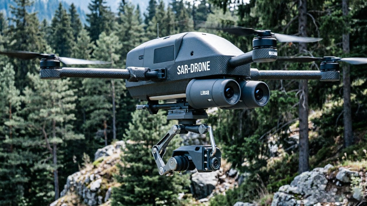
Thermal-only drone deployments leave rescue teams navigating structurally unknown environments — a dangerous gap that rescue drone LiDAR technology is now closing for good.
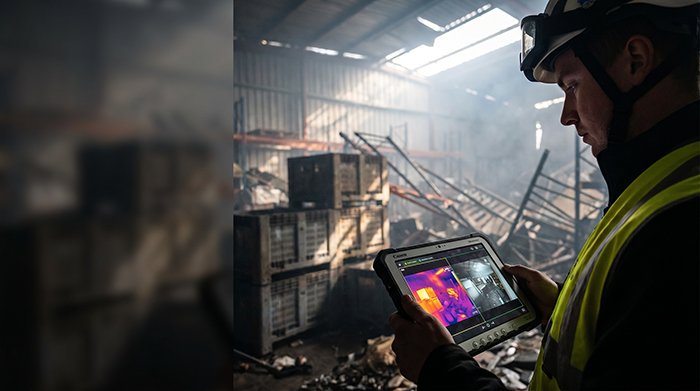
Picture a warehouse fire. Dense smoke has cut visibility to zero. A thermal camera picks up a heat signature through the haze, but the reading is ambiguous — is the source a survivor trapped behind a concrete partition, or a person in an open corridor just 10 feet from an exit? Without geometric data, that distinction is invisible. The crew acts on incomplete intelligence, and every second spent guessing costs lives.
Thermal sensors excel at detecting heat — and fail completely at understanding space. They produce 2D radiometric images that convey temperature gradients but carry no depth information, no surface geometry, and no structural integrity data. A drone relying solely on thermal imaging cannot determine whether a detected signature is in an accessible room or sealed behind a collapsed wall. It cannot measure standoff distances, assess floor stability, or build a usable map of the environment. In cluttered, smoke-filled conditions, that sensor blindness translates directly into what operators call “blind flying” — maneuvering a UAV through an unknown structure with no spatial reference frame.
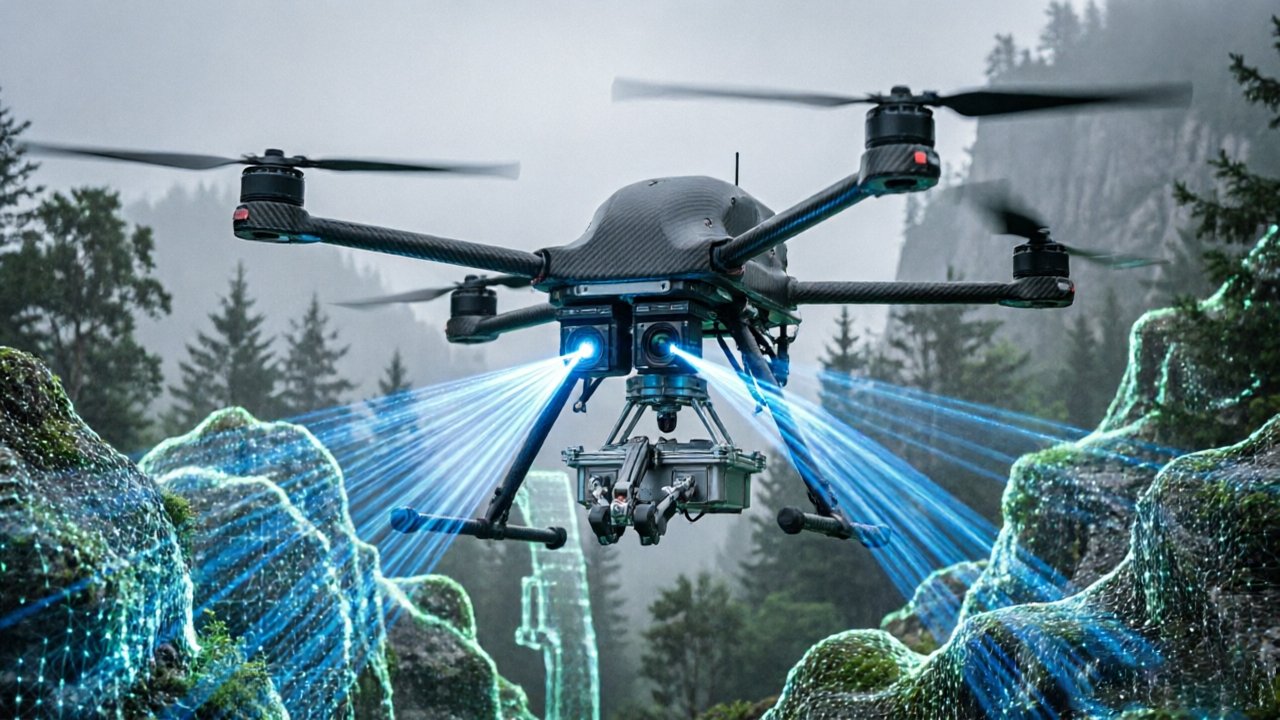
The problem compounds when thermal signatures become actively misleading. Heat radiating through a masonry wall can read nearly identically to a survivor in an open hallway. Without geometric context, the thermal image provides a signal but no reliable interpretation. As the IEEE Xplore Digital Library notes, “the combination of thermal and LiDAR sensors transforms a drone from a simple camera platform into a sophisticated spatial intelligence tool capable of indoor and outdoor structural analysis.” LiDAR provides the spatial layer that thermal imaging fundamentally lacks — generating real-time dense 3D point clouds that map surfaces, obstacles, and structural voids regardless of lighting or smoke conditions. That capability is what makes sensor fusion not a luxury, but an operational necessity.
How LiDAR actively enables navigation when visual conditions collapse entirely is where the technology’s true advantage becomes clear.
How LiDAR Enables Navigation in Degraded Visual Environments (DVE)
LiDAR cuts through smoke, dust, and darkness to map solid surfaces in real time — a capability no passive sensor can replicate under true emergency conditions.
Active vs. passive sensing is the core distinction here. Thermal cameras and RGB imagers are passive — they depend entirely on energy already present in the environment, whether heat radiation or ambient light. LiDAR is fundamentally different. It fires its own laser pulses and measures the time each pulse takes to return after striking a surface, building a precise 3D point cloud independent of lighting or visual clarity. As explored in the context of aerial mapping applications, this active architecture means LiDAR produces true structural data rather than a photographic interpretation of a scene.
Particulate penetration is where this physics pays off in a rescue context. Smoke and fog particles scatter visible and near-infrared light differently depending on wavelength. LiDAR systems operating at longer wavelengths — typically 905 nm or 1550 nm — experience significantly less scattering from fine airborne particulates than RGB cameras do. The result: a drone flying through a burning building’s smoke layer can still resolve walls, doorframes, and floor edges with centimeter-level fidelity, even when a human eye or optical camera sees nothing useful.
BVLOS reliability compounds this advantage in unpredictable environments. According to the Center for Robot-Assisted Search and Rescue (CRASAR), LiDAR sensors enable rescue drones to navigate beyond visual line of sight in smoke-filled or degraded visual environments where GPS is also unreliable. This BVLOS capability — driven by LiDAR’s onboard spatial awareness capabilities capabilities capabilities capabilities capabilities capabilities — means the drone doesn’t need external positioning signals to stay oriented. It builds its own real-time 3D safety corridor, detecting structural hazards and maintaining flight paths autonomously. That combination of thermal imaging and LiDAR fusion for drones creates the reliable navigational backbone that thermal-only platforms simply cannot provide — which is exactly where the two sensors begin to work as a unified system.
The Synergy of Thermal Tracking and LiDAR Mapping
Dual-sensor fusion transforms raw heat signatures into precisely located, structurally verified victim positions — making UAV LiDAR for search and rescue fundamentally more actionable than thermal imaging alone.
When thermal and LiDAR data merge, the result isn’t just a better map — it’s a decision-ready operational picture. Thermal sensors flag biological heat anomalies, while LiDAR simultaneously builds a centimeter-accurate 3D point cloud of the surrounding environment. The fusion layer overlays those heat signatures directly onto the structural model, creating what operators call “life-sign hotspots”: precise coordinates tied to real architectural context — a collapsed corridor, a debris pocket, a sealed room.
Structural verification is where this pairing earns its weight in field conditions. Before a rescue team advances into a fire-damaged building, commanders need to know whether a floor will hold. LiDAR’s high-resolution surface modeling can reveal load-bearing deformations, voids, and structural discontinuities that a thermal image simply cannot detect. Sending personnel into an unverified zone based on a heat bloom alone is a calculated risk that dual-sensor fusion eliminates. According to NIST, LiDAR-equipped drones can generate centimeter-level accurate 3D terrain models up to 10 times faster than traditional ground-based surveying — a speed advantage that directly compresses the critical window between victim detection and safe extraction.
The practical benefits of this fused approach compound quickly in the field:
- Centimeter-level victim localization — coordinates accurate enough to guide hand-tool excavation
- Real-time structural hazard flagging — LiDAR identifies unsafe zones before team entry
- Reduced redundant sweeps — hotspots are pinned to the map, eliminating re-search of cleared areas
- Shareable situational awareness — fused data exports directly to incident command systems
Systems with high vertical channel counts — explored in detail in this breakdown of dense point cloud capabilities — produce the resolution density needed for this level of victim localization. For teams evaluating sensor hardware, LidarStar’s 3D sensor catalog offers platforms purpose-built for fusion-ready deployments.
The same multi-echo scanning logic that gives LiDAR its edge in collapsed structures applies even more dramatically when the operating environment shifts from concrete rubble to dense tree canopy — a scenario the next section examines in depth.
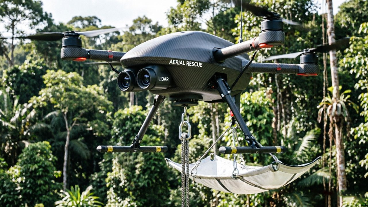
Forest Floor Penetration: SAR in Dense Vegetation
Wilderness SAR operations face a challenge that urban rescues don’t — a living, layered ceiling of vegetation that blocks every passive sensor on the market.
Multi-echo LiDAR changes that equation entirely. Unlike a single-return laser that bounces off the first surface it contacts, multi-echo systems fire a pulse, and record multiple return signals from the same beam path. The first echo captures the canopy top, subsequent echoes pass through gaps in the foliage, and the final return hits the ground. This is the same principle that answers the question of how does LiDAR help drones see through smoke — layered, partial obstruction is simply noise to be filtered, not a wall. The result is a complete picture of what exists beneath the tree line, rendered in real time. What that produces operationally is a Digital Terrain Model (DTM) — a bare-earth representation stripped of all vegetation data. While the LiDAR unit is reconstructing the forest floor geometry, the thermal sensor runs simultaneously, scanning for biological heat signatures at the canopy gaps and edges. According to the Journal of Unmanned Vehicle Systems, dual-sensor payloads enable this exact “Forest Floor Penetration” workflow, where LiDAR filters through dense canopy to map the ground while thermal sensors detect heat signatures below.
The DTM layer reveals what heat alone never could. A missing person collapsed in a ravine, a depression behind a fallen tree, a hollow obscured by root structures — none of these features radiate enough thermal contrast to flag on a heat sensor. But the LiDAR-derived terrain model makes them structurally visible. Rescuers reviewing the fused data can cross-reference a heat signature and its micro-terrain context simultaneously, dramatically narrowing ground team deployment.
Example scenario: A hiker goes missing in a densely canopied Pacific Northwest forest. A dual-sensor UAV surveys the area, its LiDAR stripping canopy returns to expose a creek-bed depression invisible from above. The thermal layer registers a faint heat bloom in that exact location. Ground teams move directly to the site — no grid search required.
That kind of precision depends on data being available the moment the drone lands — which raises a critical question about sensor methodology. Not all aerial mapping approaches deliver that, and the gap between real-time point clouds and post-processed alternatives matters enormously when rescue windows are measured in hours.
Why LiDAR Beats Photogrammetry in Rescue Scenarios
Understanding why use LiDAR instead of photogrammetry for rescue comes down to one brutal constraint: time. When a missing person’s survival odds drop by the hour, any sensor technology that requires ideal conditions or post-processing delays is a liability, not an asset.
Photogrammetry simply wasn’t designed for the conditions that define rescue operations. The technique stitches overlapping photographs into 3D models, which demands consistent ambient light, sufficient texture contrast, and significant processing time after the flight. At night, in smoke, or beneath a canopy — the exact scenarios covered in earlier sections — photogrammetry yields incomplete or unusable data. Low-texture environments compound this further. Uniform snow fields, ash-covered rubble, and flooded terrain all lack the visual markers that photogrammetric algorithms depend on for accurate point matching.
LiDAR sidesteps every one of those dependencies. Pulsed laser returns generate a dense point cloud in real time, regardless of lighting conditions or surface texture. Operators see an accurate 3D map of the environment as the drone flies, not hours later. In rescue operations governed by the “Golden Hour” principle — where the first 60 minutes after a traumatic event dramatically determine survival outcomes — this immediacy is non-negotiable. Photogrammetry’s post-processing lag, which can stretch from 30 minutes to several hours depending on dataset size, is a delay that SAR coordinators simply cannot afford.
There’s also the critical question of safe passage verification. As noted by the IEEE Xplore Digital Library, LiDAR provides the geometric data necessary to confirm that a path is structurally safe for a human rescue team to follow after the drone has scouted it — a task photogrammetry struggles to perform reliably in low-light conditions. The same real-time spatial reasoning that powers autonomous navigation in complex environments applies directly here: precise, reliable geometry when the margin for error is zero.
That real-time 3D awareness becomes even more powerful when machine intelligence is layered on top — which is exactly where the technology is heading next.
Integrating AI with Dual-Sensor Payloads
AI is rapidly becoming the third pillar of dual-sensor rescue operations — the intelligence layer that turns raw fused data into actionable detections, faster than any human operator can manage alone.
Automated AI analysis of dual-sensor data is what converts a powerful hardware setup into a genuinely autonomous detection system.
Thermal target tracking is where AI makes its first and most immediate impact. Modern deep learning models can monitor thermal feeds in real time, flagging heat signatures that match human body temperature ranges and flagging them for operator review within seconds. As The Conversation notes, drones paired with AI could help SAR teams find missing persons faster by automating the identification of anomalies in complex datasets — a critical advantage when every minute counts.
Reducing operator cognitive load is equally important. During a high-stress grid search, a single pilot may be managing flight path, battery status, and two simultaneous video feeds. AI-driven detection overlays mean the system alerts the operator to candidates rather than requiring the operator to scan every frame manually. What typically happens is that teams catch more victims and make fewer attention-related errors when AI handles the triage layer.
False positive filtering is where LiDAR’s shape recognition earns its keep alongside AI. Thermal cameras alone regularly misidentify warm rocks, exhaust vents, or sun-heated debris as human targets. When AI cross-references a thermal hit against LiDAR’s 3D point cloud — checking for the geometric profile of a human torso — spurious alerts drop dramatically. This same cross-modal logic drives advances in other AI-navigation domains; spatial mapping for autonomous systems follows a nearly identical sensor-fusion principle.
AI-ready hardware matters because the algorithms will keep improving. Choosing a payload with open SDK access and sufficient onboard compute ensures that mission commanders can push updated detection models to the drone without replacing the entire sensor stack — a consideration that ties directly into the hardware procurement decisions covered in the next section.
{{YOUTUBE_EMBED_PLACEHOLDER: AI dual-sensor drone SAR detection demo}}
Hardware Considerations for Factory-Direct Procurement
Choosing the right LiDAR hardware for SAR drones isn’t just a technical decision — it’s a procurement strategy that directly affects mission readiness, budget control, and long-term reliability.
Triple-certified sensors are non-negotiable for industrial SAR deployment. Certifications such as CE, FCC, safety, and environmental compliance. In rescue operations where hardware failure can mean a missed detection, certification is a baseline guarantee that the unit performs within documented tolerances under real-world stress. Weight and power draw are the two constraints that separate a viable UAV payload from a grounded drone. Most mid-class SAR platforms carry a practical payload ceiling between 400g and 1.2kg. A sensor that pushes past that threshold forces hard trade-offs — shorter flight times, reduced battery margins, or a heavier airframe with higher operating costs. Low-power LiDAR units that draw under 10W while maintaining 100m+ range keep those trade-offs manageable, preserving flight endurance when it matters most.
Eliminating intermediaries is where procurement strategy becomes a budget multiplier. Distributor markups on specialized sensor hardware can add 20–35% to unit cost without adding any technical value. Sourcing directly from the manufacturer compresses that margin back into your project budget — freeing capital for redundant units, spares inventory, or integration development. LidarStar’s sensor catalog for SAR applications reflects factory-direct pricing on triple-certified LiDAR hardware, removing the reseller layer entirely.
Global support and replacement guarantees close the reliability loop. A 24-hour support commitment and guaranteed replacement availability mean that a hardware failure in the field doesn’t ground an entire SAR fleet for weeks. In practice, knowing replacement units ship within a defined window allows program managers to plan spares budgets rather than scramble during active deployments.
Taken together, these four hardware considerations — certification depth, payload efficiency, direct sourcing, and support infrastructure — form the procurement checklist that separates mission-capable SAR systems from expensive shelf hardware. The next section draws these threads together into actionable takeaways for developers building or scaling dual-sensor rescue platforms.
The Bottom Line: Key Takeaways for SAR Drone Developers
Dual-sensor fusion isn’t a nice-to-have upgrade — it’s the operational baseline that separates drones capable of completing a rescue from ones that turn back when conditions get hard.
The relationship between thermal and LiDAR is built on complementary strengths, not redundancy. Thermal imaging identifies the target; LiDAR ensures the drone survives the environment to reach it. Thermal excels at detecting body heat through darkness and light foliage, but it can’t tell a drone where the cliff edge is, how dense the canopy has become, or whether the next 10 meters of flight path is navigable. As CRASAR has noted, LiDAR provides the geometric “eyes” needed to navigate where GPS, vision fail — a statement that carries real weight in the rubble, smoke, and dense terrain where SAR missions actually happen. Speed is survival. LiDAR’s real-time 3D mapping capability generates scene data roughly 10x faster than traditional ground surveying, which directly compresses response time inside the critical Golden Hour. Every minute shaved from site assessment is a minute added to a victim’s odds. For multi-sensor fusion architectures, this speed advantage only holds if the data pipeline between sensors is tight — which is why hardware selection and system integration must be treated as a single decision, not two separate ones.
BVLOS operations demand fusion, not choice. Smoke, dense fog, and thick vegetation all degrade thermal accuracy while simultaneously creating the obstacle environments where LiDAR earns its cost. Teams operating beyond visual line of sight can’t afford to lose situational awareness when atmospheric conditions shift mid-mission.
On the procurement side, sourcing factory-direct hardware reduces per-unit cost without compromising the triple-certified reliability that regulators and mission commanders require. The same principle that drives autonomous boundary mapping in commercial robotics — precision sensing without unnecessary overhead — applies equally here.
The takeaways above reflect the core reasoning built throughout this article. If questions remain about specific performance limits, payload weights, or environmental boundaries, the next section addresses the most common ones directly.
Frequently Asked Questions About Rescue Drone LiDAR
Dual-sensor fusion raises practical questions for SAR teams evaluating hardware — here are the answers that matter most before deployment.
Can LiDAR see through solid walls?
No — and understanding this limitation is just as important as knowing what LiDAR can do. LiDAR pulses cannot penetrate solid concrete or dense building materials. What the technology can do is rapidly map an entire structure’s exterior geometry, identifying doorways, windows, collapsed sections, and viable entry points with centimeter-level accuracy. In a building collapse scenario, that structural map is often what directs a rescue team to the safest and fastest route in, making the limitation far less critical than it first appears.
How does weather affect dual-sensor drones?
Weather is the most operationally variable factor in SAR performance. Rain and fog scatter both LiDAR pulses and thermal radiation, reducing effective range. However, dual-sensor platforms have a built-in advantage: when thermal performance degrades in heavy precipitation, LiDAR’s point-cloud accuracy often remains effective at shorter ranges, and vice versa in dry, cold conditions where thermal contrast sharpens. Teams should treat weather as a planning variable rather than a mission blocker, adjusting flight altitude and speed to compensate.
What is the typical weight of a LiDAR-thermal payload?
Most integrated LiDAR-thermal payloads designed for SAR drones fall between 0.4 lbs and 1.8 lbs, depending on sensor resolution and housing. Lightweight configurations preserve flight endurance, which directly affects search coverage per battery cycle — a critical factor in time-sensitive rescues.
Is LiDAR better than thermal for finding people?
Neither sensor wins alone. As research published in the Journal of Unmanned Vehicle Systems confirms, LiDAR filters through dense canopy to reveal hidden structures and obstacles while thermal identifies biological heat — two complementary data streams that, when fused, dramatically outperform either sensor operating independently. The goal isn’t to choose between them; it’s to deploy them together.
Rescue outcomes improve when technology decisions are grounded in operational reality. Teams ready to move beyond single-sensor limitations should evaluate dual-sensor platforms as the new operational baseline for modern SAR missions.