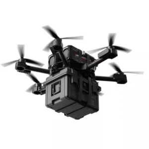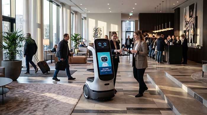
Service robots that can’t adapt to a crowded hotel lobby in real time aren’t autonomous — they’re expensive obstacles. This is why LiDAR SLAM service robots are rapidly replacing first-generation automated systems, and why 3D spatial mapping has become the defining capability separating functional hospitality robotics from truly intelligent ones.
SLAM — Simultaneous Localization and Mapping — is the process by which a robot builds an internal map of its environment while simultaneously tracking its own position within that map. In a hospitality context, this happens continuously and in real time, across floors, corridors, and event spaces that change by the hour.
Early deployments relied on 2D LiDAR, which captures a single horizontal plane of data — effective in static, controlled warehouses, but brittle in layered commercial environments. A hotel restaurant presents overhanging furniture, split-level flooring, and guests moving unpredictably in three dimensions. A flat scan plane simply misses most of it. 3D LiDAR, by contrast, captures full vertical and horizontal spatial data, enabling robots to interpret their surroundings as a volumetric environment rather than a flat diagram. The difference in practical reliability is substantial — as explored in how spatial coverage underpins SLAM accuracy.
Modern guest expectations have accelerated this shift. Hotel and restaurant operators now demand robots that respond gracefully to spontaneous human activity — not systems that freeze or reroute awkwardly when a luggage cart crosses their path. “Automated” implies a fixed routine; “autonomous” implies intelligent adaptation.
As the International Federation of Robotics notes: “The transition from 2D to 3D LiDAR SLAM is the critical leap required for service robots to move from ‘automated’ to ‘truly autonomous’ in unpredictable human-centric spaces.”
That unpredictability — especially the challenge of moving obstacles — is where the real technical complexity begins.
Solving the ‘Dynamic Noise’ Problem in Restaurants and Hotels
Dynamic environments are the single biggest threat to reliable autonomous navigation for hospitality robots — and without a strategy to filter moving objects from static structure, even a well-mapped hotel lobby becomes a source of constant localization failure.
Moving noise — guests pushing luggage carts, servers weaving between tables, clusters of pedestrians shifting at check-in — creates what engineers call “map ghosting.” When a robot’s SLAM system records a moving person as a permanent feature, the resulting map is polluted with phantom obstacles that don’t exist seconds later. Over time, these ghost features compound, degrading the robot’s positional confidence and forcing costly re-mapping cycles.
3D LiDAR directly addresses this in two important ways. First, its vertical scanning range captures spatial data across multiple height planes simultaneously. This matters for identifying low-profile hazards that 2D scanners simply miss:
- Chair legs extending below table height into travel paths
- Glass partitions that reflect or pass through 2D laser beams
- Overhanging table edges that create collision risks above the scan plane
- Low luggage racks and cart bases in corridors and lobbies
Second, point cloud density gives the system the contextual depth to distinguish between a permanent wall and a temporary obstacle like a standing crowd. Sparse returns that shift between scans are classified as dynamic and excluded from the static map layer — a process that keeps the reference map stable even during peak service hours.
According to research published in the MDPI Sensors Journal, 3D LiDAR-based SLAM can achieve localization error margins of less than 10cm indoors — a meaningful improvement over 2D-only approaches that struggle once human traffic picks up. As explored further in how 2D and 3D sensors compare, that vertical dimensionality is what makes the difference in real-world performance.
Of course, LiDAR alone isn’t enough. The next challenge is maintaining accurate pose estimates when the sensor’s line of sight is temporarily blocked — which is where sensor fusion becomes essential.
Multi-Sensor Fusion: Integrating LiDAR with IMU and Odometry
No single sensor delivers reliable autonomous navigation alone — and in hospitality environments, the gaps between sensor inputs can mean the difference between a smooth delivery run and a stalled robot blocking a hotel corridor.
IMU (Inertial Measurement Unit) sensors fill the critical gap when LiDAR point clouds become unreliable. During occlusion events — a staff member stepping in front of the scanner, a glass elevator shaft reflecting beams erratically — the IMU maintains trajectory estimation by tracking acceleration and angular velocity at hundreds of Hz. It essentially acts as a short-term memory, bridging the moments when visual or spatial landmarks disappear.
Wheel odometry handles a different challenge: featureless stretches. Long service corridors with identical wall panels offer almost nothing for LiDAR to anchor on. In these scenarios, odometry provides dead reckoning data — distance and heading estimates derived from wheel rotation — to keep the robot’s position estimate from drifting into uncertainty.
The fusion of these inputs requires sophisticated mathematical frameworks. Extended Kalman Filters (EKF) have historically been the standard approach, probabilistically weighting each data stream based on its estimated noise characteristics. Increasingly, Factor Graph Optimization is replacing EKF in high-precision mapping for commercial robotics applications, offering better accuracy over longer timeframes by jointly optimizing all sensor inputs rather than processing them sequentially.
Bold callout: Multi-sensor fusion combining 3D LiDAR with IMU and wheel odometry is essential for maintaining centimeter-level mapping accuracy in dynamic hospitality environments, according to IEEE Xplore research.
This fusion architecture also directly prevents the “kidnapped robot” problem — where a robot loses positional context after being moved or bumped — by cross-referencing multiple independent data streams to rapidly re-establish localization. As robots operate across larger footprints, understanding how maps stay coherent over time becomes equally critical, which is where loop closure mechanics come into play.
The Mechanics of Loop Closure in Large-Scale Venues
Loop closure is the mechanism that separates a reliable 3D LiDAR SLAM system from one that slowly loses its way across a large venue.
Cumulative drift is an unavoidable byproduct of odometric navigation. Over time, small measurement errors compound — a robot completing a 500-foot circuit through a convention hotel may return to its starting point with a positional error large enough to misalign its map by several feet. Loop closure corrects this by recognizing a previously visited location and snapping the map back into alignment, as research in robotics and autonomous systems confirms.
In large-scale hospitality spaces, landmark recognition drives effective loop closure. Distinctive architectural features — columns, elevator banks, service alcoves — serve as anchors. When a robot’s 3D LiDAR SLAM for indoor environments re-encounters these landmarks, the SLAM algorithm compares the current scan against stored map segments and applies a global pose correction. The richer and more geometrically distinct those landmarks are, the more reliably closure triggers.
There’s a practical trade-off, however. Frequent loop closure checks are computationally expensive, creating latency that can momentarily slow navigation. Engineers typically balance this by triggering closure detection only when scan similarity scores drop below a defined threshold — reducing overhead without sacrificing accuracy.
Multi-floor mapping introduces an additional layer of complexity. Elevators, stairwells, and ramps create vertical transitions that 2D mapping simply can’t resolve. Robust SLAM implementations maintain separate floor-level submaps linked by vertical localization anchors, preserving consistency between levels. As covered in earlier sections, fusing LiDAR with IMU data is critical here — the IMU’s pitch and roll readings help disambiguate elevation changes during transitions.
Understanding how maps stay consistent over distance sets the stage for the next challenge: ensuring that individual scan frames match that map with maximum precision in real time.
Optimizing Scan Matching for High-Precision Mapping
Scan matching is the algorithmic engine behind 3D LiDAR SLAM — and choosing the right approach directly determines how to improve mapping accuracy in hotel robots operating across complex, crowded environments.
As noted by the Neurealm Technical Blog, 3D LiDAR SLAM utilizes scan matching to align successive point clouds, creating a cohesive 3D representation of the environment. Two algorithms dominate this process:
- Iterative Closest Point (ICP): Aligns point clouds by minimizing the distance between corresponding points. Computationally elegant, but sensitive to initial pose estimates and prone to drift in repetitive or feature-sparse spaces like long corridors and symmetrical ballrooms.
- Normal Distributions Transform (NDT): Represents the environment as a set of statistical distributions rather than raw points. NDT handles sparse features more robustly and converges faster in large open areas — making it a stronger default for hospitality deployments.
Frame-to-map matching takes this further by comparing each incoming LiDAR scan against the accumulated global map rather than just the previous frame. This approach dramatically reduces drift over long operational runs, keeping position estimates stable as a robot completes repeated delivery loops across a hotel floor.
3D point clouds also resolve a critical ambiguity that 2D systems struggle with: feature-poor environments. A lobby with identical columns or a featureless corridor offers few geometric landmarks. The vertical dimension of a 3D scan — ceiling heights, fixture profiles, architectural overhangs — adds discriminating structure that anchors localization even when horizontal geometry repeats.
GPU acceleration has become essential for processing the high-density point clouds that precision mapping demands. Modern LiDAR units can generate millions of points per second, and GPU-parallel processing pipelines compress scan matching latency to under 10 milliseconds — a prerequisite for real-time navigation.
The choice of sensor hardware, however, shapes what’s computationally possible — a consideration the next section addresses directly.
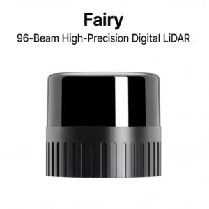
Hardware Selection: Why Factory-Direct LiDAR Matters for R&D
Choosing the right LiDAR sensor isn’t just a technical decision — it’s a procurement strategy that shapes how quickly you can scale a robot fleet across a commercial property.
Sensor type trade-offs begin with the three primary categories. Mechanical LiDAR units deliver the widest field of view and proven point-cloud density, making them the default for large hotel lobbies and convention floors. Solid-state sensors offer a lower profile and reduced moving parts, which translates to longer service intervals in high-cycle deployments. MEMS-based systems split the difference — compact and fast-scanning, but sometimes constrained in range. As discussed in earlier sections on scan matching and loop closure, the SLAM pipeline is only as good as the raw data feeding it, so sensor selection cascades directly into mapping accuracy.
Safety certification is non-negotiable in commercial environments. Triple-certified sensors — carrying CE, FCC, and RoHS compliance — satisfy the baseline requirements that hotel operators and their insurers typically demand before any autonomous platform goes live. Cutting corners here creates downstream liability exposure that no R&D budget can absorb.
Factory-direct sourcing addresses a problem that surfaces fast during scaling: inconsistent hardware, inflated margins, and slow technical escalation paths. Consider the following strategic advantages of working directly with manufacturers:
- Consistent hardware batches — identical firmware and calibration profiles across every unit in a fleet
- Factory-direct pricing — removes distributor markup, freeing budget for integration and testing
- Engineering-level support — direct access to the teams who designed the sensor, not just a reseller helpdesk
- Global reach — suppliers like LidarStar partner directly with manufacturers such as RoboSense and Hesai to deliver this access to engineers in over 26 countries
Integration support becomes critical the moment you’re tuning Hesai or RoboSense hardware against a custom SLAM stack. Understanding how SLAM maintains accuracy over long operating cycles is one thing; having manufacturer engineers available when a driver conflict surfaces at 11 PM before a hotel opening is another. That kind of support only comes through a direct sourcing relationship.
With the right hardware pipeline established, the next step is translating these components into a working deployment — which requires a disciplined implementation roadmap.
Practical Implementation: A Roadmap for Hospitality Developers
Launching a service robot deployment without a structured implementation plan is the fastest route to expensive rework — here’s a phased workflow that keeps projects on track.
A disciplined, phase-by-phase approach separates successful hotel robot rollouts from costly do-overs. With sensor selection and SLAM fundamentals covered in earlier sections, the focus now shifts to execution.
- Environmental assessment and sensor placement. Begin with a thorough site survey — map ceiling heights, doorway widths, reflective surfaces, and peak congestion zones. At this stage, integrate blind compensation sensors alongside the primary LiDAR. As noted in the LidarStar Product Catalog, integrating blind compensation sensors is critical for detecting objects in the immediate vicinity that main LiDARs might miss — a non-negotiable consideration in lobbies and tight corridor transitions.
- Initial mapping run and manual map cleanup. Conduct baseline mapping runs during off-peak hours. Export the raw point cloud, then manually flag and remove dynamic artifacts — luggage carts, parked equipment, temporary signage — that will corrupt long-term navigation.
- Tuning SLAM parameters for dynamic obstacle rejection. Adjust voxel filter resolution, ICP convergence thresholds, and dynamic object exclusion radii based on the venue’s specific traffic profile. For venues with complex multi-floor layouts, real-time SLAM fundamentals provide useful context on continuous map updating strategies.
- Stress testing in high-traffic scenarios. Simulate peak conditions — convention check-ins, breakfast rushes, event egress — before go-live. Log localization error rates and trigger manual review for any drift exceeding your defined centimeter-level threshold.
[EMBED: "Service Robots in Hospitality: Changing Hospitality Forever!" — https://www.youtube.com/watch?v=VzYEFdPpX60]
Each phase builds directly on the last. Completing this roadmap methodically sets up the consolidated principles covered next.
Key Takeaways for High-Precision Service Robotics
3D LiDAR SLAM has moved from experimental technology to operational necessity for any service robot expected to perform reliably in a busy hospitality environment.
The implementation roadmap and hardware guidance covered in earlier sections all point toward the same conclusion: precision is non-negotiable. Centimeter-level accuracy is no longer a premium feature — it’s the baseline requirement for robots operating in high-traffic commercial zones. A guest-facing robot that misjudges distance by even a few inches can obstruct a corridor, collide with luggage, or trigger a safety shutdown that disrupts service.
Here are the four principles every robotics developer and hospitality operator should carry forward:
- 3D LiDAR is the foundation. Unlike 2D alternatives, 3D sensors capture full volumetric data — detecting rolling carts, crouching children, and low-profile obstacles that flat-plane scanning misses entirely. Dynamic, human-centric venues demand this depth.
- Multi-sensor fusion is the production baseline. Combining LiDAR with IMU and odometry data closes the accuracy gap that any single sensor leaves open. Exploring sensor fusion approaches for robotics early in the design cycle prevents costly architecture rework later.
- Loop closure prevents long-term drift. In large-footprint venues — convention wings, sprawling lobbies, multi-zone kitchens — loop closure is the primary mechanism keeping maps accurate over thousands of operational hours.
- Factory-direct procurement scales R&D budgets further. Eliminating distributor markup means more budget allocated to sensor redundancy, software iteration, and field testing — all of which compound into better outcomes. Hybrid sensor architectures are easier to prototype when hardware costs stay predictable.
The technology is proven. The implementation patterns are established. What remains are the specific questions teams encounter when moving from concept to deployment — and those deserve direct answers.
Frequently Asked Questions About LiDAR SLAM
3D LiDAR SLAM remains the most common source of technical questions among hospitality robotics teams — here are the answers that matter most.
Q: What is the difference between 2D and 3D LiDAR for SLAM?
2D LiDAR scans a single horizontal plane, which works in simple, static environments but misses obstacles above or below that plane. 3D LiDAR captures a full volumetric point cloud, giving robots genuine spatial awareness of ramps, luggage, seated guests, and low-hanging fixtures. Understanding how spatial intelligence evolved from flat-plane scanning to full 3D mapping explains why modern hospitality deployments now default to 3D systems.
Q: How does LiDAR SLAM handle glass walls in hotels?
Glass is genuinely one of SLAM’s harder challenges — laser pulses can pass through or scatter unpredictably off reflective surfaces. Modern 3D LiDAR sensors can be tuned to better handle reflective surfaces like glass, though multi-sensor fusion remains the best safeguard, according to LidarStar Technical Support. Combining LiDAR with depth cameras or ultrasonic sensors fills the perception gaps that glass creates.
Q: Can service robots use SLAM for multi-floor navigation?
Yes — with the right integration. SLAM handles per-floor mapping reliably, while elevator API integration and floor-transition logic manage vertical movement between levels. In practice, each floor maintains its own map layer, and the robot localizes within the correct layer based on floor-sensor confirmation.
Q: Why is factory-direct hardware better for robotics startups?
Factory-direct procurement cuts out distributor markups, typically reducing per-unit sensor costs significantly and shortening lead times. More importantly, direct relationships give engineering teams access to firmware updates, calibration support, and custom configurations — advantages that off-the-shelf distribution channels rarely offer, especially during iterative early-stage development.