An autonomous pallet mover weighing several tons traveling at 12 mph doesn’t have the luxury of hesitation — and neither does the worker who steps into its path.
Modern factory floors have undergone a fundamental redesign. Where automation once lived behind cages and safety fencing, today’s operations favor collaborative floor plans where AGVs, robots, and human workers share the same aisles, the same loading docks, and the same split-second windows of space. The operational efficiency gains are undeniable. So are the risks.
Traditional proximity sensors were never built for this environment. Ultrasonic sensors struggle with interference from heavy machinery and conveyor noise. Passive infrared detectors — designed to sense body heat — lose reliability near heat-emitting equipment like welding stations or ovens. In the high-noise, thermally complex landscape of a modern distribution center, both technologies generate false positives that trigger unnecessary stops and, critically, false negatives that miss real threats entirely. Neither can resolve the geometry of a moving object with enough precision to distinguish a worker’s outstretched arm from a passing cart.
That detection gap has pushed many facilities toward stop-and-go safety protocols — essentially programming machines to halt whenever uncertainty exceeds a threshold. The safety logic is sound. The throughput consequences are not. Repeated micro-stops compound across a shift, eroding the productivity gains that justified automation investment in the first place. A LiDAR collision avoidance systems changes this calculus entirely: instead of defaulting to a full stop, the system makes an informed, geometry-based decision in milliseconds.
Response time is the variable that separates near-misses from incidents. Research on occupational safety in human-robot collaboration consistently points to reaction latency as a primary injury factor. LiDAR-based systems can significantly reduce industrial vehicle accidents in high-traffic mixed environments — not by stopping more, but by seeing more accurately. Understanding how that spatial awareness is constructed — through volumetric mapping rather than flat detection planes — is where the real engineering story begins.
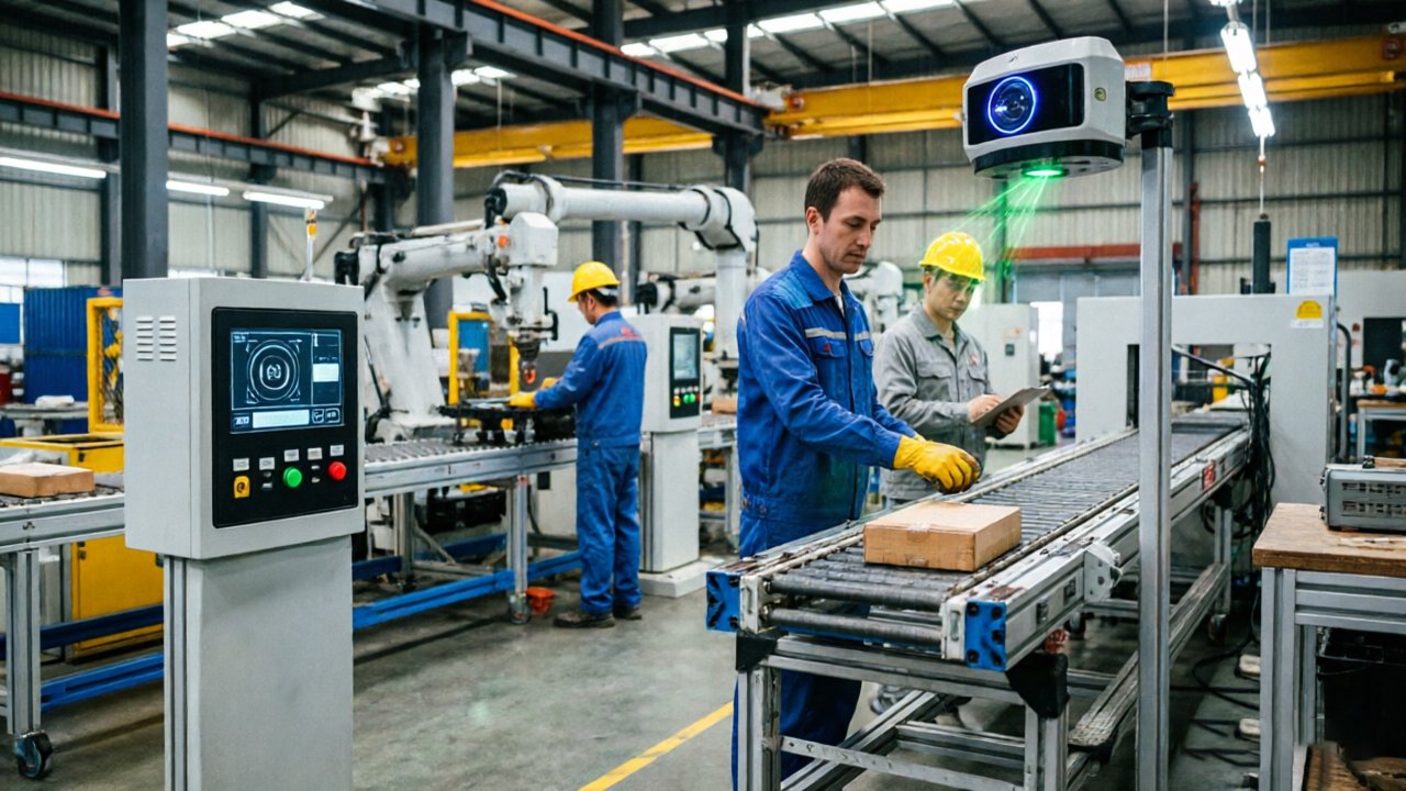
Creating the ‘Safety Bubble’: How 3D LiDAR Maps Volumetric Risk
3D LiDAR detects more than just what’s in front of a robot — it builds a living, breathing map of every cubic inch of space the machine occupies and travels through.
The fundamental problem with 2D sensors is that hazards don’t exist in a single plane. A traditional 2D LiDAR scanner reads a flat horizontal slice of the environment — useful for detecting objects at floor level, but completely blind to a forklift’s raised mast swinging overhead or a robotic arm extending laterally at shoulder height. According to NIST’s guidance on robotic systems safety, 3D LiDAR creates a “Safety Bubble” that explicitly accounts for vertical height, capturing the full threat geometry of forklift masts, hanging infrastructure, and overhead robotic movements. This is why a robust forklift proximity warning system built on 3D sensing can flag a raised load long before it enters a worker’s path — something no 2D system can reliably do.
Point cloud density is what separates detection from understanding. A 3D LiDAR unit firing millions of laser pulses per second returns a dense volumetric point cloud — essentially a real-time 3D sculpture of the environment. Within that cloud, algorithms distinguish a human worker’s irregular, moving silhouette from the flat, rectangular geometry of a static pallet. The difference in point distribution, reflectivity, and motion signature makes misclassification far less likely than with camera-only or 2D approaches. You can explore how this translates to AGV navigation ROI in mixed-flow environments to understand the broader operational payoff.
Sensor hardware matters too. Mechanical LiDAR units use rotating mirrors to sweep a wide field of view — effective but potentially vulnerable to vibration on heavy industrial equipment. Solid-state LiDAR, with no moving parts, offers greater durability for forklift mounting and high-vibration robotic arms. Each type has tradeoffs in range, resolution, and cost, making sensor selection a critical engineering decision.
The richness of that 3D data, however, only delivers its safety promise when processed fast enough to matter — which is precisely where sensor fusion becomes the next challenge.
Sensor Fusion: Why LiDAR and Camera Detection Must Work in Real-Time
Sensor fusion isn’t a feature enhancement — it’s the foundational architecture that transforms AGV safety sensors from reactive tools into genuinely intelligent perception systems.
LiDAR and cameras provide complementary information. LiDAR provides the “where” — precise distance, depth, and volumetric positioning down to centimeters, regardless of what the object actually is. Cameras provide the “what” — color, texture, shape, and contextual classification. Neither is sufficient on its own. A LiDAR point cloud can detect an obstacle in an aisle but can’t confirm whether it’s a stationary pallet or a worker crouching to pick something up. A camera can identify a human silhouette but loses reliability in the high-glare corners and poorly lit staging areas common in large distribution centers.
The fusion of these two data streams enables what researchers describe as semantic perception — the robot’s ability to interpret its environment with contextual meaning. According to research on LiDAR-based semantic perception for forklifts, the integration of LiDAR and camera detection fusion allows autonomous vehicles to distinguish between a pedestrian and a structural pillar, a critical capability when milliseconds determine whether an emergency stop is necessary.
Real-time processing demands of fusion algorithms are significant. A functional pipeline typically handles:
- Point cloud ingestion from spinning or solid-state LiDAR at 10–20Hz
- Image frame synchronization to match camera captures temporally with LiDAR scans
- Object classification using onboard neural inference hardware
- Probabilistic confidence scoring to flag detections before triggering braking
“The goal of semantic perception isn’t just object detection — it’s building a machine understanding of intent and context within a shared space.”
Reducing false positives matters as much as catching real hazards. Unnecessary emergency stops degrade throughput, introduce mechanical wear, and — ironically — train workers to ignore warning events. Fusion reduces these ghost-stops by cross-validating detections: if LiDAR flags a mass in the travel path but the camera classifies it as a hanging safety banner with no depth variance over time, the system holds course. This cross-validation loop, processed in real time via dedicated onboard compute architectures, is what separates mature fusion systems from single-sensor workarounds.
Of course, fusion pipelines are only as reliable as the operating environment allows — and warehouse environments are rarely static or clean. That raises a challenge that LiDAR handles differently than cameras do when ambient light becomes an uncontrolled variable.
The Environmental Advantage: Accuracy Under 100,000 Lux
3D LiDAR industrial safety performance holds up where every other optical sensor starts to fail — inside the punishing light environments of modern manufacturing facilities.
High-intensity LED arrays and overhead skylights are optical adversaries for traditional infrared sensors. Passive infrared systems rely on detecting the heat differential or reflected IR signature of nearby objects. When ambient light floods a facility at peak levels, the sensor’s dynamic range saturates, producing false negatives at exactly the moments reliable detection matters most. Skylights that pour unfiltered sunlight across a warehouse floor don’t just challenge a sensor — they functionally disable it.
Time-of-Flight physics explains why LiDAR escapes this trap. A ToF LiDAR unit fires a precisely timed laser pulse and measures the interval before it returns. The calculation is purely temporal — it doesn’t depend on the brightness of the surrounding environment. According to the IEEE Xplore Digital Library, 2D ToF LiDAR sensors maintain high measurement accuracy in ambient light levels reaching 100,000 lux — roughly equivalent to direct tropical sunlight. That’s the physical ceiling of natural illumination, meaning ToF-based systems are functionally immune to environmental lighting shifts across all 24/7 shift rotations.
Dusty and high-vibration zones introduce a separate challenge. Particulate matter — metal shavings, sawdust, cement particles — can scatter laser returns and degrade point cloud integrity. Manufacturers address this through multi-return signal processing, which interprets layered reflections rather than discarding ambiguous data. Vibration, meanwhile, affects sensor mounting stability; industrial-grade housings with shock-damping enclosures keep beam alignment within tolerances even on forklift masts or conveyor gantries. Understanding where single-sensor systems show strain reinforces why environmental robustness at the hardware level is non-negotiable.
The reliability implication across shift rotations is straightforward: a facility running dawn-to-midnight operations sees lighting conditions swing dramatically. LiDAR’s time-domain measurement model means the safety zone performs identically at high noon under skylights as it does during a third-shift blackout. That consistency is precisely what makes it the foundation for deployment decisions — which brings the conversation naturally to how existing industrial trucks integrate these systems in practice.
Retrofitting vs. Native Integration: Implementing Forklift Proximity Systems
Retrofitting existing industrial trucks with 3D LiDAR is often the fastest path to a safer factory floor — without waiting on a full fleet replacement budget.
Hardware mounting is the first physical constraint to solve. Industrial forklifts present limited flat mounting surfaces, vibration-heavy mast assemblies, and exposure to dust and moisture. Sensors require IP67-rated enclosures and shock-dampened brackets positioned to cover the vehicle’s forward travel zone, rear swing arc, and lateral blind spots. A common pattern is mounting one forward-facing unit at bumper height and a secondary rear unit to manage reversing hazards — a configuration that mirrors the 360° perimeter coverage approach increasingly standard in mobile safety platforms.
VCU integration is where retrofitting gets technically demanding. The LiDAR data stream must interface with the vehicle’s existing controller via CAN bus or Ethernet, translating point-cloud proximity alerts into actionable speed reduction or stop commands. The critical technical requirement: latency between obstacle detection and brake actuation must stay below 100ms to meet functional safety thresholds. One practical approach is using a dedicated edge compute module — a safety-rated bridge device — that handles sensor fusion robotics logic locally before passing filtered commands to the VCU, rather than routing raw point-cloud data through the vehicle’s native processor.
GNSS bridging matters for large-scale facilities with outdoor yard operations and indoor dock transitions. In these mixed environments, GPS positioning supplements LiDAR-based localization during the brief outdoor segments where indoor reference maps don’t apply, then hands off seamlessly as the vehicle re-enters the building.
Cost-benefit reality: as MicroVision Insights notes, retrofitting delivers immediate safety upgrades without the capital expenditure of fleet replacement — often at 20–30% of the cost of purchasing new AGVs. However, retrofitting does carry integration labor costs and compatibility risks that native deployments avoid.
Understanding how these systems respond after detection — whether they stop abruptly or adapt intelligently — is what the next section addresses.
From Reactive Braking to Proactive Path Planning
Factory floor automation safety reaches its ceiling when robots can only react — LiDAR breaks through that ceiling by giving machines the spatial foresight to act before a hazard becomes a crisis.
The difference between a reactive system and a proactive one is measurable in both safety outcomes and operational efficiency. Emergency stops are costly in ways that extend well beyond the moment they trigger. Every abrupt halt strains drivetrain components, degrades braking mechanisms, and shortens the service life of motors and wheels. Over thousands of daily cycles across a fleet of AGVs, that mechanical wear compounds into significant unplanned maintenance costs. A 3D LiDAR system feeding continuous environmental data into path-planning algorithms allows vehicles to decelerate gradually, reroute around emerging obstacles, and maintain forward momentum — rather than slamming to a standstill and restarting from zero.
As the International Federation of Robotics notes, “the integration of LiDAR into industrial safety protocols shifts the paradigm from reactive braking to proactive spatial awareness.” That shift is the core argument for why LiDAR belongs at the foundation of any serious human-robot collaboration strategy, not bolted on as an afterthought.
Predictive obstacle avoidance in AGVs works by analyzing point cloud data in real time to project likely collision paths and adjust trajectories before danger materializes. When paired with real-time environmental mapping, vehicles can dynamically recalculate routes as workers move through shared aisles — treating human presence as an input to navigation rather than an interruption to it.
The human factor here is often underappreciated. Workers who watch robots lurch and stop unpredictably develop a kind of ambient anxiety that erodes confidence and slows their own movement. Predictable, smooth robot behavior builds trust on the shop floor. When workers understand how an AGV will respond to their proximity — because it consistently slows and steers rather than stopping dead — they move more naturally, coordinate more effectively, and report higher comfort levels in shared workspaces.
That combination of mechanical efficiency, adaptive routing, and human-centered behavior is only possible when the underlying sensor data is rich enough to support it. The specific functions that translate LiDAR data into those real-world outcomes are worth examining in closer detail.
Common LiDAR Functions for Industrial Machinery: A Technical Checklist
LiDAR’s value on the factory floor extends far beyond a simple “stop when something’s close” trigger — it delivers a layered suite of functions that transform how industrial machines perceive, decide, and act.
According to Outsight Industrial Insights, typical LiDAR functionalities on industrial machinery encompass safety zone monitoring, navigation, and volumetric object profiling — each function reinforcing the others in a tightly integrated system.
Area monitoring and dynamic safety zones form the first layer. Rather than fixed perimeters, LiDAR continuously redraws protective boundaries based on machine speed, load, and the detected positions of workers. If a pedestrian enters a warning zone, the system can trigger an audible alert; a further incursion into the inner zone initiates a controlled stop — all without any physical barrier.
Object profiling for automated pallet handling takes spatial awareness a step further. By generating dense 3D point clouds, LiDAR accurately measures the dimensions, orientation, and surface condition of a pallet before a forklift engages. This removes the guesswork from approach angles, reduces tip-overs, and enables consistent autonomous load acquisition even with irregularly stacked inventory.
Navigation and SLAM integration is where LiDAR becomes a true cognitive tool. Simultaneous Localization and Mapping allows an AMR or AGV to build and continuously update a real-time 3D map of its environment, correcting for shifted racks, newly parked equipment, or unexpected obstacles — without GPS or pre-mapped routes.
Speed monitoring based on proximity thresholds closes the loop. As a detected object moves closer, the system progressively reduces machine velocity — from full speed, to cautious creep, to a full stop — matching response precisely to risk level rather than applying a binary on/off brake.
These four functions don’t operate in isolation; together, they constitute a complete spatial intelligence stack. Understanding what each layer contributes sets the foundation for evaluating the broader performance and safety outcomes LiDAR delivers — which is exactly where the bottom line comes into focus.
The Bottom Line: What You Need to Know
LiDAR has moved from a niche sensing technology to the defining safety infrastructure for any factory floor where humans and robots share space.
The core takeaway: no single sensor technology matches LiDAR’s combination of range, resolution, and environmental consistency for protecting human workers in real-time.
360-degree spatial awareness is where the argument begins. Unlike 2D laser scanners or fixed cameras, modern industrial LiDAR systems — including 128-channel 3D configurations — construct a continuous, high-resolution point cloud of everything within the robot’s operating envelope. Complex warehouse environments with intersecting aisles, moving conveyors, and unpredictable foot traffic demand that level of coverage. Cameras struggle with depth accuracy; 2D sensors miss vertical hazards entirely. LiDAR sees all of it.
Sensor fusion elevates that foundation into something more intelligent. Pairing LiDAR with camera input creates a system that doesn’t just detect an object — it classifies it. That distinction between a human worker and a pallet stack is the difference between a near-miss and a stopped production line. As explored in this breakdown of fusion architecture, combining sensor modalities produces a coherent environmental picture that neither technology achieves alone. According to OSHA safety guidance, layered detection approaches are the foundation of effective machine safeguarding.
Lighting immunity is a practical advantage that often gets underestimated. LiDAR operates consistently up to 100,000 lux of ambient light, meaning night shifts, welding arcs, and skylight glare don’t degrade performance. Camera-only systems routinely fail under these conditions.
Operational impact ties everything together. Facilities implementing LiDAR-based proximity systems report accident reductions of up to 70%, with the added benefit of fewer unplanned stoppages disrupting throughput. Safety and efficiency, in this case, move in the same direction.
If questions remain about specific deployment scenarios — sensor behavior in dusty environments, range requirements for forklifts, or how to weigh 2D versus 3D cost tradeoffs — those practical details are worth examining closely.
Frequently Asked Questions About Factory LiDAR Safety
LiDAR’s growing role on factory floors raises practical questions that engineers and safety managers need answered before committing to a deployment.
Q: How does LiDAR perform in dusty or smoky factory conditions?
Multi-echo LiDAR largely solves the contaminated-air problem. By firing a single pulse and analyzing multiple light returns — one from an airborne particle, another from the solid surface behind it — sensors can effectively “see through” dust and steam that would blind a standard camera system. According to SICK Sensor Intelligence, this multi-echo capability is specifically designed for industrial environments where airborne particulates are unavoidable. That said, extremely dense smoke or heavy spray can still degrade signal quality, so pairing LiDAR with redundant sensing in the harshest zones remains a best practice. For a deeper look at filtering strategies, managing signal loss in tough conditions is worth reviewing before specifying hardware.
Q: Can LiDAR be used for both safety and navigation simultaneously?
In practice, yes — but with an important caveat. Safety-rated LiDAR outputs are governed by strict timing and integrity requirements under standards like IEC 61496, meaning the safety channel cannot be shared with navigation tasks that might introduce latency. The common architecture uses a single physical sensor that feeds two separate software pipelines: one certified safety output and one navigation output. Integrating both data streams cleanly through a ROS-based middleware layer is a well-established approach on collaborative platforms.
Q: What range is typically needed for forklift collision avoidance?
Forklifts traveling at standard warehouse speeds of 5–8 mph require a detection zone of roughly 15–25 feet to allow safe deceleration. High-speed aisle environments push that requirement toward 40 feet.
Q: How do 2D and 3D LiDAR sensors compare on cost-to-performance?
2D sensors remain the cost-efficient default for floor-level perimeter guarding, typically running $500–$2,000 per unit. 3D sensors, ranging from $3,000 to $15,000+, justify their cost when overhead hazards, crouching workers, or complex geometries make a single scan plane inadequate. The decision comes down to the specific geometry of your shared workspace — not a blanket preference for one technology over the other.