Payload weight is one of the most consequential variables in multi-rotor UAV design — and the engineering community has the data to prove it. Every 100 grams of additional payload can reduce flight time by 2% to 5% depending on battery capacity and rotor configuration, according to Drone-OSS. That figure compounds quickly when you consider […]
Category: Lidar
Industrial Drone LiDAR vs. Consumer Sensors: Why Accuracy Matters
When evaluating ppk drone mapping, it’s important to understand the key differences. A rangefinder measures distance. A mapping-grade UAV LiDAR system captures a georeferenced, three-dimensional model of the world — and that distinction determines whether your data is usable or not. Consumer drone sensors are largely engineered for obstacle avoidance and flight safety, not rigorous […]
Drone LiDAR for Power Line Inspection: Why Precision Matters
Passive imaging fails power line inspection at the most fundamental level — it depends entirely on contrast, and a 5mm conductor against a gray sky offers almost none. Photogrammetry reconstructs 3D geometry by matching visual features across overlapping photographs. That process works reasonably well for broad, textured surfaces. It breaks down completely when the target […]

Why Multi-Return LiDAR is Essential for Accurate Forest DEMs
Multi-return LiDAR forestry applications depend on a deceptively simple principle: a single laser pulse can produce multiple distinct echoes as it travels through a forest canopy. The laser doesn’t pass through leaves — it passes through the gaps between them. As the NOAA Office for Coastal Management explains, “the ability of LiDAR to ‘see through’ […]

LiDAR vs. Photogrammetry: Choosing the Best for Terrain Mapping
Two fundamentally different technologies power modern terrain mapping — and understanding that gap is the fastest way to see why the lidar vs photogrammetry debate isn’t really a debate at all for dense environments. LiDAR is an active sensor. It fires its own laser pulses toward the ground and measures the time each pulse takes […]

Solid-State LiDAR: Reducing BOM Costs for Cleaning Robots
Commercial cleaning robotics has crossed a threshold: the market no longer rewards innovation points on a spec sheet — it rewards margin discipline at scale. The US commercial cleaning robots market is maturing fast, and with that maturity comes brutal pressure on hardware costs. Facility managers and fleet operators aren’t buying one robot — they’re […]

Why Standard LiDAR Fails on Port AGVs: Marine-Grade Solutions
Port automation AGV LiDAR systems are operating in one of the most punishing industrial environments on earth — yet most are built to standards that assume a factory floor. The shift from manual to automated horizontal transport has reshaped modern port logistics. Where dockworkers once guided straddle carriers and terminal tractors by hand, automated guided […]
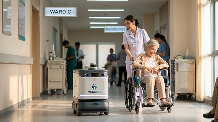
Why 3D LiDAR Is Essential for Medical Delivery Robot Navigation
Hospital corridors are among the most unforgiving navigation environments on earth — and most robotic systems aren’t built for them. A warehouse floor follows predictable patterns. A sidewalk, while variable, moves slowly. But a hospital corridor operates on an entirely different level of complexity. Nurses pivot mid-stride, supply carts appear from alcoves, and patients in […]
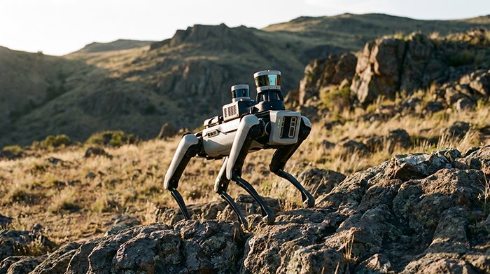
3D LiDAR for Quadruped Robots: Mastering Terrain Perception
Modern quadruped robots are crossing a fundamental threshold — moving from stumbling through environments reactively to reading terrain before a single foot falls. Early legged systems operated in what researchers simply called “blind” locomotion. Without any external sensory input, robots relied entirely on proprioceptive sensing — inertial measurement units (IMUs) and leg odometry — to […]

Mastering ROS LiDAR Integration: A Plug-and-Play Guide
Most robotics developers waste weeks chasing hardware-specific quirks when the real power of ROS is that it was designed to make the sensor almost irrelevant. That design philosophy is what makes ROS LiDAR integration so compelling in practice. Rather than building your navigation stack around a specific sensor’s SDK, ROS abstracts the hardware behind standardized […]