A single misaligned pallet can halt an entire automated storage aisle, cascade into failed retrieval cycles, and cost a facility thousands of dollars in downtime before a technician even arrives on the floor.
The shift to full automation removes the human safety net. In a manually operated warehouse, a forklift driver notices a skewed pallet and compensates with a quick steering adjustment. In an AS/RS stacker crane environment, that margin disappears entirely. The crane executes precision pick-and-place cycles within tolerances measured in millimeters, traveling vertically and horizontally along fixed rails to deposit or retrieve loads at speeds a human operator could never match. A pallet rotated just a few degrees off-axis isn’t a minor inconvenience — it’s a direct collision risk.
Legacy proximity sensors compound the problem. Standard photoelectric or inductive sensors detect the presence of an object but cannot distinguish between a pallet stringer, a shadow, accumulated dust, or wrapping film hanging off a load. That inability to read pallet geometry means the crane’s control system operates on incomplete data, relying on programmed coordinates that assume every pallet arrived perfectly square. In practice, that assumption fails regularly.
The downstream consequence is the “dry run” — a fault-triggered abort where the crane withdraws without completing a cycle, returns to a home position, and waits for operator intervention. Each dry run can consume three to five minutes of productive cycle time, and in high-throughput facilities, these events stack up fast. Research from a recent industry study indicates that automated warehouses using high-precision positioning sensors achieve a significant increase in throughput over facilities relying on basic proximity sensing alone.
Closing that performance gap starts with solving the pallet recognition problem at its source — which is exactly where LiDAR pallet positioning technology enters the picture.
How 3D LiDAR Solves the Skewed Pallet Recognition Problem
3D LiDAR transforms raw spatial data into precise fork-positioning commands, giving every AS/RS pallet recognition system the geometric intelligence needed to handle real-world pallet variability.
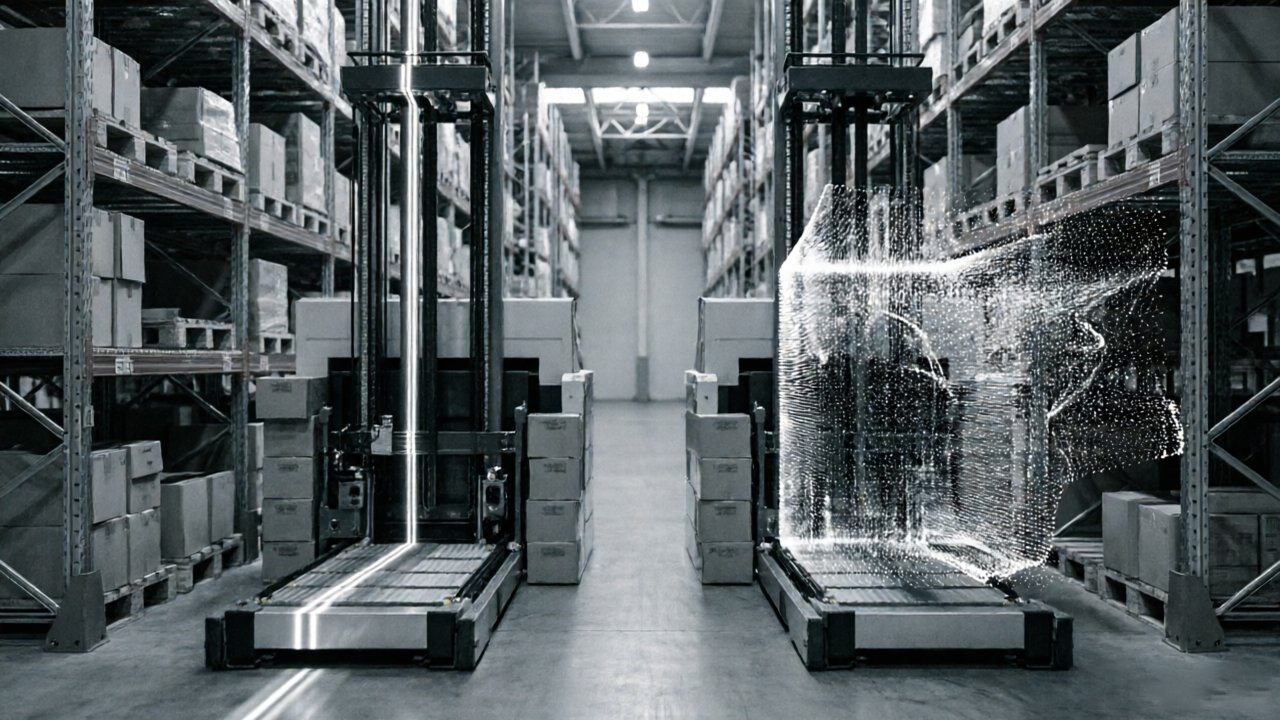
Where 2D laser scanners capture a single horizontal plane, 3D LiDAR captures a dense volumetric point cloud — millions of coordinate measurements per second that collectively describe the full geometry of a pallet face, its pocket openings, and any deformation along its structure. That raw data feeds directly into onboard algorithms designed to calculate the exact center of each pallet pocket in real-time, even when a load has shifted, rotated slightly off-axis, or settled unevenly on a rack beam. According to recent research for stacker cranes, translating point cloud geometry into actionable XYZ crane fork coordinates is now a core requirement for safe, high-throughput automated retrieval.
Volumetric mapping is the critical differentiator here. A 2D scan produces a line; a 3D scan produces a shape. That shape carries depth, surface texture, and edge definition — all the cues a recognition algorithm needs to distinguish a clean pocket entry from an obstructed or damaged one. In practice, this means the crane doesn’t need a “perfect” pallet to operate safely; it needs enough geometric data to make a confident positioning decision.
As the automation industry experts has noted, the shift from 2D to 3D LiDAR in pallet handling is driven specifically by the need to manage non-standard variables without stopping the line. Those variables include:
- Broken or missing stringers that distort the expected pocket geometry
- Plastic stretch wrap that obscures entry edges and creates false depth readings
- Non-standard pallet dimensions outside GMA or EUR spec tolerances
- Load overhang where product extends beyond the pallet footprint
- Deck board gaps that create ambiguous surface profiles
“The shift from 2D to 3D LiDAR in pallet handling is driven by the need to manage ‘non-standard’ variables — such as broken stringers and plastic wrap — without stopping the line.” — automation industry experts
Each of these conditions would either confuse a 2D scanner or require a manual exception workflow. A 3D point cloud, processed through modern segmentation algorithms, resolves them automatically by evaluating the full pocket volume rather than a single cross-sectional slice. That distinction becomes especially consequential as facilities aim for higher efficiency — a challenge the next section explores in depth.
Integrating LiDAR for High-Density Deep-Lane Storage
High-density deep-lane storage pushes automated warehouse pallet detection to its absolute limits, where clearances measured in centimeters separate a successful cycle from a costly rack collision.
Pallet shuttle racking systems demand positional accuracy that few sensor technologies can consistently deliver. In these configurations, pallets travel deep into multi-position lanes — sometimes 10 or more positions back — stacked on rails with lateral clearances that can fall below 50mm on each side. The crane’s forks must enter cleanly, every single time, without drifting into adjacent lane guides or clipping the load beams above. As industry experts note, LiDAR-based pallet positioning systems utilize 3D point cloud data to detect the precise center and orientation of pallet pockets even when skewed — a capability that becomes especially critical when a pallet has shifted slightly during a previous shuttle cycle.
Tight tolerances compound across depth. In standard single-deep racking, a small angular error in pallet orientation is manageable. In deep-lane storage, that same error multiplies with every inch the forks travel inward. Continuous spatial monitoring through LiDAR allows the system to dynamically correct fork trajectory mid-approach rather than committing to a fixed path calculated at the aisle entry point. This real-time adjustment is what prevents racking damage that, left unchecked, accumulates into structural fatigue requiring expensive repair or full bay replacement.
Long-range LiDAR, however, tells only part of the story. Navigation-grade LiDAR — mounted to manage aisle travel and gross positioning — lacks the angular resolution needed to resolve sub-centimeter pocket alignment at the final pick-and-place stage. The last few inches of fork insertion require a different layer of sensing entirely, one focused specifically on pocket geometry and load edge detection. That gap in coverage is precisely what introduces collision risk in high-speed operations — and it points directly to why blind spot compensation around the fork head deserves its own dedicated treatment.
The Role of Blind Spot Compensation in Stacker Crane Safety
Standard LiDAR configurations on stacker cranes create a predictable vulnerability: the closer the forks get to a pallet, the less reliable the sensor data becomes.
The blind spot problem is a geometry issue. Long-range navigation LiDAR is optimized for wide-field scanning across an aisle — it builds the spatial map that drives positioning decisions. But as forks close within roughly 200–400mm of the target pallet face, the sensor’s effective detection zone collapses. Reflections scatter, scan angles become oblique, and point cloud density drops precisely when accuracy matters most. This is the same window where a slightly skewed pallet — the kind that makes engineers ask how to detect skewed pallets in AS/RS systems — can cause a fork tip to clip an adjacent racking frame or neighboring load.
Blind Spot Compensation directly addresses this gap. According to the industry publications, LiDAR sensors with Blind Spot Compensation are critical for stacker cranes to ensure safety and precision during the final inches of the pick-and-place cycle. Short-range proximity sensors — typically safety-rated Class 2 or higher — take over from navigation LiDAR at close range, providing continuous feedback through the insertion stroke.
Bolded callout: The safest stacker cranes use two complementary sensor layers — one for navigation, one for the final approach — because no single sensor optimally covers both ranges.
In practice, a well-integrated system coordinates these layers through three technical requirements:
- Handoff thresholds that trigger proximity sensor authority at a defined distance, typically under 500mm
- Safety-rated outputs that command an immediate stop if the proximity sensor detects unexpected contact geometry
- Real-time fork angle correction driven by proximity data before full insertion occurs
High-speed operations add further pressure. At elevated cycle rates, the window between detection and contact compresses significantly, making sensor handoff latency a critical engineering parameter.
Of course, collision avoidance isn’t limited to positioning geometry alone. The physical condition of the pallet itself — warped boards, loose wrap, or overhanging loads — introduces a separate class of risk that even precise fork alignment can’t fully solve.
Evaluating Pallet Condition: Beyond Simple Positioning
LiDAR pallet positioning for high-density racking does more than tell a stacker crane where a pallet is — it reveals whether that pallet is safe to handle at all.
3D point cloud data can flag a structurally compromised pallet before it ever enters the racking system, transforming the sensor suite from a navigation tool into an active quality control layer. Where earlier sections explored how blind spot compensation protects against collision during retrieval, this capability shifts the defense line even further upstream — to the inbound stage.
Damaged pallet detection is one of the clearest practical gains. A broken bottom board or cracked stringer alters the pallet’s point cloud profile in ways that a calibrated 3D sensor can detect at intake. According to the automation industry experts, 3D LiDAR provides the depth perception necessary to distinguish between the pallet structure and environmental noise like shrink wrap — which matters enormously when a partially collapsed corner might otherwise pass a 2D camera check unnoticed.
Loose plastic wrap and load overhang represent a separate but equally disruptive failure mode. Overhang as small as 2–3 inches can clip a rack beam during storage or retrieval, triggering safety stops that ripple through the entire system’s throughput. LiDAR detects these protrusions as deviations from the expected load envelope, allowing the WCS to flag or reroute the affected pallet before the crane ever commits to a travel path.
Preventative maintenance is where this data earns compounding value. Over time, condition-flagging logs identify which pallet types, suppliers, or receiving docks consistently generate non-conforming loads. That pattern recognition converts raw sensor data into an operational intelligence asset — one that reduces the “lost inventory” events caused by pallet failures deep inside the rack, where manual retrieval is costly and disruptive.
Translating that rich 3D data into real-time decisions, however, demands a tightly engineered pipeline between the sensor array and the crane’s control system — which is exactly where the technical implementation conversation begins.
Technical Implementation: From Point Cloud to PLC
Getting LiDAR data from sensor to action requires a tightly engineered pipeline — one where latency, compatibility, and signal clarity all have to work in concert.
The entire value of 3D LiDAR depends on how fast and cleanly the system can convert raw point cloud data into actionable positioning commands. As industry experts note, AS/RS systems must process volumetric data in real-time to reliably distinguish a pallet from the surrounding racking frame — a task that demands serious computational throughput at the edge, not just back at the server.
Data throughput is the first constraint engineers encounter. Modern 3D LiDAR sensors can generate millions of points per second. For real-time pallet recognition on a moving stacker crane, the onboard processor needs to filter, segment, and classify that data within milliseconds. Any lag between scan and response translates directly into positioning error — or worse, a collision.
PLC and WCS integration is where most implementation projects encounter friction. LiDAR systems output structured data (typically via Ethernet/IP or PROFINET), but legacy AS/RS PLCs were often designed around simpler encoder-based inputs. Bridging this gap usually requires a middleware layer or edge computing module that translates point cloud outputs into discrete positioning signals the PLC can act on. Coordination with the Warehouse Control System (WCS) ensures that corrected pallet positions propagate upstream before a retrieval cycle commits.
Environmental noise filtering adds another layer of complexity in live warehouse settings. Dust, forklift exhaust, rapid lighting changes, and reflective racking surfaces all introduce false returns in the point cloud. Effective implementations apply statistical outlier removal and intensity thresholding at the sensor firmware level before data even reaches the PLC.
Multi-sensor calibration ties it all together. When a stacker crane carries two or more LiDAR units — one for approach detection, one for fine fork alignment — their reference frames must be precisely co-registered. Calibration protocols typically involve scanning a fixed target array at multiple crane positions and iterating until spatial offsets fall within sub-millimeter tolerances.
The sophistication of this pipeline sets the stage for something broader: as warehouse throughput demands increase, the architecture built here becomes the foundation for more adaptive, AI-driven perception systems.
Future-Proofing Your Warehouse with 3D Perception
Upgrading from 2D to 3D sensing is no longer a competitive advantage — it’s becoming a baseline requirement for warehouses that need to scale.
2D systems are quietly throttling throughput. In high-speed fulfillment environments, 2D laser sensors struggle with pallet variability — slight tilts, inconsistent stringer spacing, and varying load heights all generate positioning errors that force the system to slow down or call for manual intervention. According to a recent industry study (Modern Materials Handling), high-precision positioning sensors eliminate the need for manual intervention when pallets are off-center, maintaining continuous flow. Every manual touch is a cycle-time killer, and in a 24/7 operation, those losses compound quickly.
3D LiDAR scales across pallet standards without reconfiguration. Whether a facility handles Euro pallets (1200×800mm), GMA/block pallets (48×40in), or mixed fleets, a 3D perception system builds volumetric profiles that adapt to each format dynamically. Rather than hardcoding reference dimensions per pallet type — a maintenance headache that grows with SKU diversity — the sensor reads real geometry on every cycle. This flexibility directly supports global logistics trends pushing warehouses toward multi-client and multi-region fulfillment models.
Reducing mechanical wear is where the TCO argument becomes concrete. Repeated fork-entry misalignments — even minor ones that don’t register as faults — accelerate wear on mast assemblies, fork carriages, and drive mechanisms. Fewer corrections per cycle means less mechanical stress per shift. Over a five-year asset lifecycle, the maintenance savings alone can offset a meaningful portion of the sensor upgrade cost.
AI and machine learning are the next frontier for pallet recognition software. Modern 3D perception platforms are increasingly paired with neural networks trained on millions of point cloud samples, enabling systems to distinguish between a pallet pocket, a shadow, and shrink-wrap noise with high confidence — even under degraded lighting or partial occlusion. As these models mature, they’ll push AS/RS reliability closer to zero-fault operation.
The practical gains across condition assessment, pipeline integration, and long-term cost management all point toward a single conclusion — one worth examining closely in the key takeaways ahead.
Key Takeaways for AS/RS Precision Positioning
3D LiDAR has shifted from an optional upgrade to a foundational requirement for any AS/RS operation that demands consistent, collision-free performance at scale.
As the sections above have shown, the gap between 2D sensing and full volumetric awareness isn’t minor — it’s the difference between a system that handles ideal conditions and one that handles reality. Here are the core ideas worth anchoring:
- 3D LiDAR resolves what 2D sensors simply cannot detect. Skewed pallets, structural deformation, and off-center loads all create positioning variables that flat-plane sensors fail to capture. Without depth data, the stacker crane is working with an incomplete picture every single cycle.
- Blind spot compensation determines final-inch accuracy. No matter how precise the travel path is, the fork approach is where collisions happen. Volumetric sensing at close range — where legacy sensors lose resolution — is the critical factor that closes the precision gap.
- Integrating 3D perception can increase warehouse throughput by up to 30%. When the system stops second-guessing pallet position and eliminates recovery cycles from misalignment events, cycle times compress and storage density improves simultaneously.
- Volumetric data lets the system distinguish real pallet pockets from shrink wrap noise. This is a distinction 2D imaging cannot reliably make — and one that directly affects how confidently the fork can commit to an entry path without risking a collision or a dropped load.
As the LidarStar Editorial Team puts it: “Precision sensing is the bridge between theoretical warehouse capacity and actual operational throughput.”
In practice, these four capabilities compound. Better pallet detection leads to fewer aborted cycles; fewer aborted cycles mean higher uptime; higher uptime closes the gap between designed capacity and actual throughput. If you’re still working through how 3D LiDAR applies to your specific setup — including legacy crane compatibility, material handling edge cases, and real-world accuracy thresholds — the next section addresses the most common questions operators ask before committing to an upgrade.
Optimizing Your AS/RS: Frequently Asked Questions
LiDAR pallet positioning raises practical engineering questions — and getting clear answers helps teams move from evaluation to confident deployment.
How does LiDAR handle transparent plastic wrap on pallets?
Stretch wrap is one of the more nuanced challenges for optical sensors. Because LiDAR pulses reflect off the surface geometry of the wrapped load rather than the wrap material itself, modern 3D sensors can still extract usable point cloud data from the pallet’s outer profile. In practice, multi-return processing — where the sensor captures both the first and last return of each pulse — helps the system distinguish the wrap surface from the pallet structure beneath it. Edge cases like heavily clear-wrapped loads benefit from sensor fusion, pairing LiDAR with depth cameras to cross-validate positioning data.
Can 3D LiDAR be retrofitted onto older stacker crane models?
Retrofit viability depends on the crane’s control architecture rather than its age. Most legacy stacker cranes can accept 3D LiDAR integration if the PLC or motion controller supports external sensor input via standard industrial protocols. As noted in industry documentation, positioning upgrades are achievable without full system replacement, though retrofits do require careful cable routing and mounting bracket engineering to preserve the crane’s existing travel envelope.
What is the typical accuracy range for LiDAR pallet positioning?
Industrial-grade 3D LiDAR systems used in AS/RS applications typically achieve positioning accuracy in the within a few millimeters under standard operating conditions — well within the tolerances required for safe slot engagement.
How do environmental factors like warehouse dust affect sensor performance?
This is a legitimate concern, but a well-managed one. Modern 3D LiDAR sensors for industrial use are rated for challenging environments and include internal filtering for optical noise, according to the industry publications. Most units carry an IP65 or higher rating, and onboard signal processing algorithms discard low-intensity returns consistent with airborne particulate rather than solid targets.