
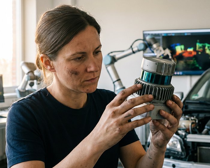
Picture this: an autonomous shuttle traveling at 45 mph encounters a debris field scattered across three lanes. Its camera system, blinded by oncoming headlights, misreads flat shadows as clear pavement. Its 2D lidar sensor sweeps a single horizontal plane and detects nothing above bumper height. The system hesitates. That half-second gap is where Level 3 autonomy breaks down — and where lives are at risk.
This isn’t a hypothetical edge case. It’s the fundamental design flaw of perception systems that lack true volumetric awareness.
Why Flat Scanning Isn’t Enough
2D LiDAR operates on a single plane, making it effective for basic obstacle detection in controlled environments. But dynamic, real-world roads are three-dimensional. A fallen ladder, a crouching pedestrian, or an overhanging truck bed simply don’t register in a flat scan. The result is a perception system with structural blind spots baked in.
Camera-based depth estimation compounds the problem. Monocular and stereo vision systems rely on contrast and texture to infer distance — a process that degrades sharply in low-light conditions, heavy rain, or direct glare. Algorithms can compensate, but they’re estimating, not measuring.
The Safety-Critical Case for 3D Mapping
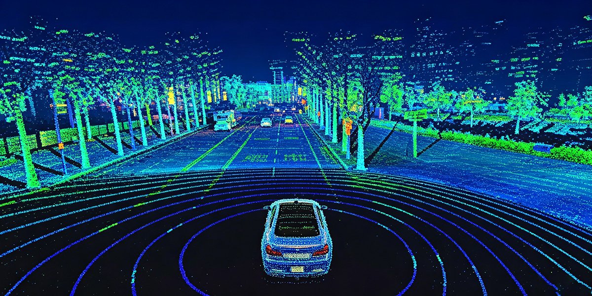
As McKinsey & Company notes, LiDAR is essential for achieving Level 3 and higher autonomous driving because it provides a precise 3D map of the environment that cameras and radar cannot replicate. The 3D point cloud isn’t a supplement to other sensor data — it functions as the ground truth that anchors every downstream decision in a robotic perception stack.
| Feature | 2D LiDAR | Camera Vision | 3D LiDAR |
|---|---|---|---|
| Depth accuracy | Single plane only | Estimated | Precise, volumetric |
| Low-light performance | Moderate | Poor | Strong |
| 3D object classification | No | Limited | Yes |
| Redundancy for safety-critical systems | Insufficient | Insufficient | Required |
The challenge of Level 3 autonomy isn’t just computational — it’s fundamentally about sensor fidelity. Without a dense, reliable point cloud, no software stack can bridge the gap between assisted driving and genuine conditional automation. The technical choices that make that possible — wavelength selection, channel count, solid-state architecture — are where the real story begins.
Technical Frontiers: 1550nm Wavelengths and Solid-State Reliability
Understanding why high-end 3D LiDAR outperforms every alternative starts at the physics level. The hardware choices baked into each automotive lidar sensor — from the laser wavelength to the scanning architecture — determine whether a system can handle real-world autonomy or just a controlled demo environment.
Wavelength Wars: 905nm vs. 1550nm
Most entry-level LiDAR systems operate at 905nm, a wavelength that’s cost-effective but carries meaningful limitations. Power output must be capped to protect human eyes, which directly restricts detection range. At highway speeds, that’s a problem you can’t engineer around.
1550nm systems change the equation entirely. According to Nature Photonics, 1550nm wavelengths deliver detection ranges exceeding 200 meters while remaining inherently safer for human vision — the cornea and lens absorb this wavelength before it can reach the retina, allowing for significantly higher emitted power. The result: longer range, stronger returns off low-reflectivity surfaces like dark asphalt or wet pavement, and better performance in adverse weather.
“The wavelength a LiDAR system uses isn’t a spec-sheet footnote — it’s the single factor that determines whether the sensor can buy enough time for an autonomous system to react.”
For high-speed transport corridors and highway pilot features, 1550nm isn’t a luxury. It’s a minimum requirement.
Mechanical vs. Solid-State: The Reliability Divide
Early rotating LiDAR units — the spinning-mirror assemblies that made the technology famous — were engineering marvels. They were also fragile, expensive to calibrate, and poorly suited for production vehicles that endure vibration, temperature cycling, and years of continuous operation.
Solid-state and Flash LiDAR architectures eliminate moving parts entirely. As documented by IEEE Xplore, this delivers measurably superior reliability in demanding industrial and automotive settings, with longer calibration longevity and drastically reduced mechanical failure risk.
The industry is moving decisively in this direction. 128-channel solid-state solutions are fast becoming the benchmark for autonomous transport platforms, offering the vertical resolution needed to distinguish a pedestrian crouching behind a parked car from background clutter — a distinction that 32- or 64-channel systems routinely miss.
The hardware foundation is only part of the story. What happens when these sensors stop operating in isolation — and start communicating with the infrastructure around them — is where the next leap in autonomous capability becomes possible.
Integrated Sensing and Communication (ISAC): The 6G Future
The conversation around autonomous perception has largely focused on what sensors can see. But the next competitive frontier is about what they can share — and how fast. As the industry accelerates toward 6G infrastructure, a paradigm shift is underway: sensors are no longer passive data collectors. They’re becoming active participants in a communication network.
What is ISAC? Integrated Sensing and Communication (ISAC) represents the convergence of sensing and wireless communication into a unified framework, where the same signals used to transmit data are simultaneously leveraged to perceive the environment at millimeter-level precision.
According to Huawei’s ISAC research, 3D LiDAR provides exactly the granular spatial resolution that 6G environments demand. This isn’t incidental — it’s architectural. Where the 3D LiDAR vs 2D LiDAR debate once centered on detection range and vertical resolution, it now extends to an entirely different dimension: whether a sensor can generate data rich enough to anchor high-precision positioning across an entire city grid.
One practical challenge that ISAC frameworks must solve is the inherent tension between sensing resolution and communication bandwidth. Denser point clouds mean more data, and more data strains the network. The resolution here is smarter edge processing — filtering and compressing point cloud data before transmission, preserving the semantic payload while reducing overhead. This is where automotive-grade 360° sensor architectures become particularly relevant, as their onboard processing capabilities align directly with ISAC’s efficiency requirements.
The smart city application extends this further. V2X (Vehicle-to-Everything) communication depends on roadside infrastructure nodes that understand geometry — not just signal presence. A LiDAR-equipped intersection can detect pedestrian trajectories, flag wrong-way vehicles, and feed live spatial data into a city’s traffic management layer simultaneously. That’s a fundamentally different value proposition than any camera or radar node can offer.
Understanding how this plays out across warehouses, mapping operations, and large vehicle blind spots is where theory becomes measurable impact.
Strategic Implementation: Mapping, Robotics, and Blind Spot Compensation
The physics and communication breakthroughs covered earlier only matter when they translate into real-world performance. With the global 3D LiDAR market projected to reach $4.7 billion by 2030 at a CAGR of 14.5%, the demand isn’t theoretical — it’s being driven by concrete deployment needs across industries. Here’s where that demand is actually landing.
High-Density 3D Mapping for Digital Twins
Urban planners and infrastructure engineers are using high-density point clouds to build digital twin environments with centimeter-level accuracy. A single LiDAR pass over a city block can generate millions of data points, creating persistent 3D models used for traffic simulation, construction planning, and emergency response staging. The density of returns matters enormously here — low-resolution scans leave gaps that become errors downstream.
AMRs Transforming Warehouse Logistics
Autonomous mobile robots (AMRs) in warehouse environments depend on 3D LiDAR to navigate dynamic, human-occupied spaces safely. Unlike 2D alternatives, 3D sensors detect low-lying pallets, elevated conveyor belts, and partial obstructions simultaneously. In practice, facilities running high-throughput fulfillment operations see measurably fewer collision incidents when upgrading from 2D to 3D perception — a direct operational ROI. The latest solid-state platforms are increasingly purpose-built for exactly this kind of mass-market robotics deployment.
Blind Spot Compensation in Large Vehicle Safety
For trucks, transit buses, and construction equipment, blind spot compensation is arguably the most safety-critical LiDAR application outside of lidar for autonomous driving on open highways. Wide-body vehicles carry substantial dead zones that cameras and ultrasonic sensors can’t fully resolve. Strategically positioned 3D LiDAR sensors fill those gaps, providing real-time volumetric awareness around the entire vehicle perimeter.
The Data Processing Challenge
None of this works without solving the throughput problem. As 3D point cloud research confirms, dense sensor arrays generate data volumes that stress onboard compute pipelines. Edge preprocessing — filtering, downsampling, and feature extraction before data hits the central processor — has become a non-negotiable architectural choice for production systems.
Sensors that generate rich data but overwhelm processing pipelines don’t improve safety — they create new failure modes.
Solving the data challenge efficiently is increasingly tied to how hardware is sourced and specified from the start — which is exactly where procurement strategy becomes decisive.
The Procurement Pivot: Direct-to-Factory Hardware Sourcing
All the architectural breakthroughs discussed so far — ISAC integration, solid-state reliability, multi-modal fusion — remain out of reach for many teams if hardware procurement doesn’t keep pace with technical ambition. The traditional LiDAR supply chain is a significant bottleneck. Distributors, regional resellers, and import intermediaries stack margins at every layer, often inflating sensor costs by 30–50% before hardware ever reaches an engineering team’s bench.
Direct-factory sourcing eliminates that intermediary tax entirely. For startups prototyping lidar for 3D mapping applications or scaling robotaxi fleets, that cost delta isn’t cosmetic — it determines whether a second hardware iteration is financially viable.
Certifications That Actually Matter
Factory-direct doesn’t mean cutting corners. Hardware carrying CE, RoHS, and SGS triple certification signals that sensors have passed independent electromagnetic compatibility, hazardous-substance, and quality-management audits. These aren’t checkbox credentials — they’re prerequisites for deployment in regulated commercial environments, from European road networks to industrial automation facilities.
Triple-certified, factory-direct sensors provide the compliance baseline that enterprise procurement teams require, without the price premium that distribution chains typically impose.
Technical Support as a Procurement Variable
One underappreciated factor is post-sale technical support. In practice, sensor integration challenges — calibration drift, ROS driver conflicts, point cloud latency — surface after purchase, not before. Sourcing directly from manufacturers means engineering support comes from teams who actually built the hardware. Detailed guidance on automotive LiDAR implementation becomes accessible rather than filtered through a reseller who may lack that depth.
Buyer’s Checklist: Evaluating Factory-Direct LiDAR
- ✅ CE, RoHS, and SGS certifications confirmed
- ✅ Direct manufacturer technical support channel available
- ✅ Performance specs (range, channels, accuracy) verified against your use case
- ✅ No hidden distribution markups in quoted pricing
- ✅ Firmware update and calibration documentation included
Balancing performance specs against budget constraints is a real engineering trade-off — and it’s one the next section’s common questions address directly.
Frequently Asked Questions About 3D LiDAR
What’s the Difference Between Mechanical and Solid-State LiDAR?
Mechanical LiDAR uses spinning components to sweep a laser across a full 360-degree field of view, delivering rich, dense point clouds. Solid-state lidar eliminates those moving parts entirely, using technologies like MEMS mirrors or optical phased arrays to steer the beam electronically. The tradeoff: solid-state units offer a narrower field of view but deliver far superior durability, lower cost at scale, and a compact form factor suited for automotive-grade deployment. In practice, many Level 3 systems combine both approaches to capture coverage and reliability simultaneously.
Can 3D LiDAR Work in Heavy Rain or Fog?
LiDAR performance does degrade in heavy precipitation — water droplets scatter laser pulses and create false returns. However, 905nm wavelength sensors handle moderate rain reasonably well, and advanced signal processing filters out much of the noise. Fog remains a more serious challenge. This is precisely why multi-modal sensor fusion with radar (which penetrates fog effectively) isn’t optional at Level 3 — it’s the architectural backstop when optical sensors are compromised.
How Many Channels Do I Need for Autonomous Driving?
For highway-speed Level 3 autonomy, 128-channel sensors are widely considered the minimum viable configuration. Fewer channels produce sparser vertical resolution, creating gaps that miss low-profile obstacles like debris or curbs. Anything below 64 channels is generally unsuitable for safety-critical decision-making at speed.
Is 1550nm Always Better Than 905nm?
Not necessarily. 1550nm delivers superior range and performs better in adverse conditions, but the components are significantly more expensive. 905nm sensors offer a proven, cost-effective path for many applications. The right choice depends on deployment range requirements and budget constraints.
How Do I Integrate 3D LiDAR with ROS Frameworks?
Most modern sensors publish data as sensor_msgs/PointCloud2 topics natively. Manufacturers typically provide ROS driver packages, making initial integration straightforward. The real complexity lies downstream — configuring point cloud filtering nodes, synchronizing timestamps across sensors, and tuning tf2 transform trees for accurate spatial alignment. A common pattern is to validate the full pipeline in simulation using tools like Gazebo before committing to physical hardware configurations.
The core truth remains: no single technology answers every challenge here, but 3D LiDAR is the irreplaceable perceptual foundation that makes reliable autonomous sensing architecturally possible at Level 3 and beyond.
Key Takeaways
- ✅ CE, RoHS, and SGS certifications confirmed
- ✅ Direct manufacturer technical support channel available
- ✅ Performance specs (range, channels, accuracy) verified against your use case
- ✅ No hidden distribution markups in quoted pricing
- ✅ Firmware update and calibration documentation included










