
Cameras lie. Not intentionally — but under a dense forest canopy at dusk, or inside a shadowed industrial corridor, a passive optical sensor simply cannot see what isn’t lit. That fundamental limitation has quietly undermined the reliability of drone-based inspection and mapping for years. The industries demanding centimeter-level accuracy can’t afford blind spots.
LiDAR-equipped drones achieve point cloud densities exceeding 1 million points per second, generating spatial data no camera-based system can replicate in low-light or vegetation-heavy environments.
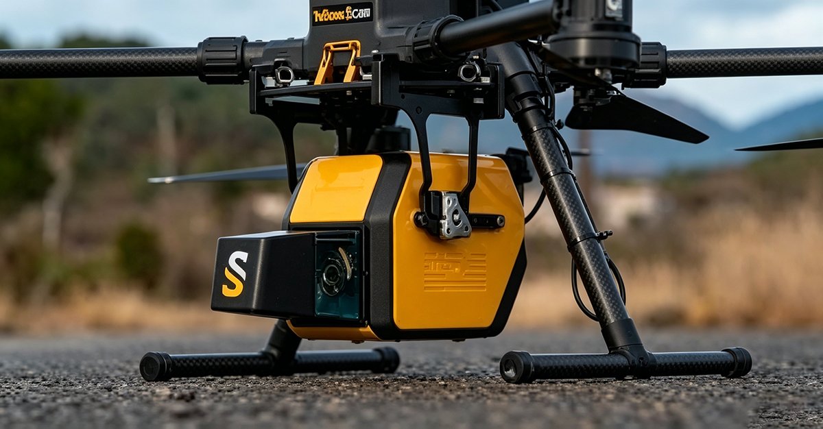
Passive vs. Active: A Fundamental Sensing Divide
Camera-based photogrammetry is a passive technology — it records light that already exists in the environment. Shadows, overcast skies, and dense vegetation canopies all degrade the data before it reaches the sensor. In contrast, drone LiDAR is an active sensing system. It fires its own laser pulses, measures their return time, and constructs a 3D picture entirely independent of ambient lighting conditions. The environment doesn’t need to cooperate.
This distinction matters enormously for industrial applications. As the USGS confirms, LiDAR pulses can penetrate dense vegetation canopies to map the underlying terrain — a capability called ground classification that photogrammetry simply cannot perform.
From Flat Images to Spatial Intelligence
The shift from 2D imagery to 3D spatial intelligence isn’t just a resolution upgrade — it’s a categorical change in what data can do. Point clouds encode precise X, Y, and Z coordinates for every surface, enabling volumetric calculations, structural analysis, and autonomous navigation pathfinding. Modern multi-sensor fusion platforms now combine LiDAR with cameras and IMUs to push this further still.
| Capability | Photogrammetry | Drone LiDAR |
|---|---|---|
| Low-light performance | Poor | Excellent |
| Vegetation penetration | None | High |
| 3D accuracy | Moderate | Centimeter-level |
| Data output | 2D/2.5D imagery | True 3D point cloud |
| Autonomous navigation use | Limited | Native |
Understanding how does drone LiDAR work at a mechanical level reveals why this performance gap is so difficult to close — and that’s exactly where we’ll go next.
How Does Drone LiDAR Work? The Mechanics of Light and Flight
Understanding why drone LiDAR outperforms passive optical systems — as established in the previous section — requires a closer look at the machinery behind the measurement. Three interlocking systems make it all possible: the laser sensor, the inertial measurement unit, and the GNSS receiver. Together, they transform a moving UAV into a centimeter-accurate mapping instrument.
The Pulse: Time-of-Flight in Motion
At the heart of every LiDAR sensor is the Time-of-Flight (ToF) principle. The sensor fires rapid laser pulses — often hundreds of thousands per second — and measures the time each pulse takes to return after striking a surface. Since light travels at a known speed, that elapsed time converts directly into distance. On a stationary tripod, this is straightforward. On a moving drone, however, the platform shifts between each pulse, which means every measurement needs a precise spatial anchor. That’s where the next two systems become indispensable.
The Position: IMU and GNSS Working in Concert
UAV LiDAR integration depends on fusing two positioning technologies simultaneously. The Inertial Measurement Unit (IMU) tracks the drone’s pitch, roll, and yaw at extremely high frequencies — compensating for turbulence, gusts, and motor vibration that would otherwise distort the point cloud. Simultaneously, a GNSS receiver (often RTK-enabled) pins each IMU reading to absolute geographic coordinates. According to ASPRS, this combination allows drone LiDAR systems to achieve vertical accuracy of 2–5 centimeters and horizontal accuracy of 1–3 centimeters — figures that rival traditional ground-based survey methods. Hardware manufacturers who invest in precision-engineered sensor components understand that the IMU and GNSS chain is only as strong as the sensor anchoring it.
The Point Cloud: Multi-Return Technology Explained
Multi-return technology is what separates drone LiDAR from simple rangefinders. A single laser pulse can register multiple returns as it penetrates vegetation — one from the canopy top, one from mid-story branches, and one from the bare ground below. Drone LiDAR captures the canopy and the forest floor in a single pass — no second flight required. This layered data capture is precisely what makes it invaluable for forestry, infrastructure, and industrial applications where occlusion would otherwise defeat a camera-based system entirely.
Of course, capturing millions of raw returns per second is only half the challenge. The real question is what happens to all that data once the drone lands — which is where automated classification workflows become critical.
The Processing Bottleneck: From Raw Data to TF-IDF Classification
Collecting billions of laser returns per flight is only half the challenge. Raw point cloud data — dense, unstructured, and massive — is operationally worthless until it’s classified, filtered, and interpreted. As GIM International notes, “the integration of LiDAR on UAVs has shifted the bottleneck from data collection to data processing, requiring automated workflows.” This is where modern 3D LiDAR sensors for drones earn their keep — not just in capture, but in the intelligence pipeline that follows.
Teaching Machines to Read a Point Cloud
One surprisingly elegant framework borrows from natural language processing: TF-IDF (Term Frequency-Inverse Document Frequency). In text analysis, TF-IDF scores a word’s importance by how often it appears in a document versus how rarely it appears across all documents. Apply that same logic to point cloud feature extraction, and you get a powerful object recognition heuristic:
Point Cloud TF-IDF Logic:

Feature "frequency" (TF)  = How densely a geometric pattern
                            (e.g., planar surface, vertical edge)
                            appears within a local scan cluster

Feature "rarity" (IDF)    = How uncommon that pattern is
                            across the full flight dataset

Classification score      = TF × IDF

High score  → Distinctive structure (power line, tree trunk, rooftop)
Low score   → Background noise or repetitive ground plane
In practice, this means a lone vertical cylinder surrounded by flat terrain scores high — flagging it as a utility pole worth isolating. Repetitive grass-level returns score low and get filtered as ground. The result is automated, scalable classification without manual labeling of every feature.
Real-Time vs. PPK Workflows
Processing timing matters as much as processing logic. Real-time workflows push classification onboard the drone, enabling immediate obstacle flagging — critical for autonomous navigation. Post-processed kinematic (PPK) workflows, however, correct GPS positional errors after the flight using ground control data, delivering centimeter-level accuracy that real-time systems can’t match.
Neither approach is universally superior. Real-time suits dynamic, safety-critical missions; PPK suits survey-grade deliverables where precision outweighs speed. Many advanced deployments combine both — streaming a low-resolution real-time feed while PPK-corrected data processes in parallel.
Understanding this processing architecture sets the stage for appreciating why specific industries — from energy infrastructure to precision agriculture — are adopting drone LiDAR at roughly 20% annual growth rates.
Industrial Applications: Where 20% Annual Growth Meets Reality
The technical pipeline covered in previous sections — from laser pulse to classified point cloud — only creates value when it solves real industrial problems. And across several sectors, drone LiDAR is doing exactly that. According to Grand View Research, the global UAV LiDAR market is projected to grow at a CAGR of over 20% through 2030 — a figure that reflects genuine operational demand, not speculative hype.
Here’s where that demand is concentrating:
- Power line inspection and wire-strike prevention. Utility corridors are notoriously dangerous for crewed aircraft. Drone LiDAR changes the equation entirely. By generating centimeter-accurate 3D models of transmission lines, towers, and surrounding vegetation, operators can identify encroachment risks, sag anomalies, and clearance violations before they become outages — or accidents. Drone mapping accuracy at this resolution is simply unachievable with optical cameras alone, especially under dense tree cover where wires are most exposed.
- Precision agriculture: beyond NDVI to 3D crop volume. Multispectral imaging tells you where a crop is stressed. LiDAR tells you how much crop is actually there. By mapping canopy height, plant density, and row structure in three dimensions, agronomists can calculate true biomass estimates, optimize irrigation zoning, and detect lodging events — all from a single flight. As Exyn Technologies notes, autonomous LiDAR mapping is increasingly integral to data-driven field management.
- Archaeological discovery through ‘digital deforestation.’ Perhaps the most visually striking application: stripping away jungle canopy digitally to reveal hidden structures beneath. This technique — used to uncover ancient Mayan cities — relies entirely on LiDAR’s ability to discriminate between ground returns and vegetation returns within the same point cloud.
Drone LiDAR doesn’t just collect data faster — it collects data that physically cannot exist in any other format.
Each of these use cases demands not just capable software, but hardware built to perform reliably in the field. That reality raises a critical question: how do you source sensors that meet the precision, durability, and compliance standards these industries require — without inflating your project budget?
Procurement Strategy: Sourcing Certified Hardware Without the Middleman
Once the right industrial application is identified — whether corridor inspection, volumetric stockpile analysis, or autonomous navigation — the next critical decision is sourcing the hardware that won’t let you down mid-project. Getting procurement wrong is expensive. Getting it right scales your operation.
Triple-Certified Hardware Is Non-Negotiable
For global deployments, certification compliance isn’t a checkbox — it’s a liability shield. Industrial drone sensors operating across North American, European, and Asian markets must meet overlapping regulatory frameworks simultaneously. Hardware that carries CE, FCC, and RoHS certifications eliminates costly re-qualification delays when a client project spans multiple jurisdictions. In practice, teams that skip this step often discover compliance gaps only after purchase orders are signed.
Why Factory-Direct Pricing Changes the Math
Scaling a drone fleet from two units to twenty is where procurement strategy becomes a genuine competitive advantage. Every intermediary layer between manufacturer and operator adds margin without adding value. Factory-direct purchasing removes that friction entirely.
The math is straightforward: distributor markups on LiDAR hardware commonly range from 15–30%. At fleet scale, that differential funds additional sensors, software licenses, or operator training. LidarStar offers certified 2D and 3D sensors at direct factory pricing with global 24-hour support — a combination that’s difficult to replicate through traditional distribution channels.
What to Look for in a LiDAR Supplier
Before committing to a vendor, evaluate against this checklist:
- ✅ Factory-direct pricing with transparent cost structure
- ✅ Both 2D and 3D sensor options under one catalog
- ✅ Multi-certification compliance (CE, FCC, RoHS minimum)
- ✅ Global technical support with defined response windows
- ✅ Documented integration specs for common drone platforms
The 2D vs. 3D decision itself — along with common technical questions about altitude limits and weather performance — deserves its own deeper look, which the next section addresses directly.
Frequently Asked Questions About Drone LiDAR
What is the maximum flight altitude for accurate LiDAR capture?
There’s no single universal ceiling, but most industrial-grade drone LiDAR systems perform optimally between 50 and 150 meters above ground level. Beyond that range, point density drops significantly — fewer laser returns per square meter means reduced resolution and less reliable classification. In practice, operators calibrate flight altitude based on the specific sensor’s range specifications, the required point density for the deliverable, and any applicable airspace regulations.
How do weather conditions like rain affect LiDAR pulses?
Rain, fog, and airborne dust scatter laser pulses before they reach the target surface, reducing both range and return quality. Heavy precipitation is the most disruptive — water droplets intercept pulses and generate false returns that contaminate the point cloud. One practical approach is scheduling missions during dry, low-wind conditions and post-processing data with noise-filtering algorithms to remove atmospheric artifacts.
Can I use 2D LiDAR for 3D mapping on a drone?
Technically yes, but the tradeoff is significant. A 2D LiDAR scanner captures a single horizontal plane of distance data; when mounted on a moving drone, that plane sweeps through space and can be reconstructed into a 3D profile — a technique called push-broom scanning. However, the resulting point cloud is far less dense and geometrically consistent than data from a purpose-built 3D multi-beam sensor, making it unsuitable for most industrial-grade deliverables.
Does drone LiDAR work in complete darkness?
Absolutely. Unlike photogrammetry, LiDAR is an active sensor — it emits its own laser pulses rather than relying on ambient light. This makes it fully operational at night, inside unlit structures, or beneath dense canopy cover where cameras fail entirely.
Drone LiDAR isn’t just a better sensor — it’s a fundamentally different way of seeing the physical world. As industrial autonomy accelerates, organizations that invest in certified hardware, rigorous processing pipelines, and application-specific workflows will move from pilot programs to operational scale. Start by defining your use case, then build the stack around it.
Key Takeaways
- ✅ Factory-direct pricing with transparent cost structure
- ✅ Both 2D and 3D sensor options under one catalog
- ✅ Multi-certification compliance (CE, FCC, RoHS minimum)
- ✅ Global technical support with defined response windows
- ✅ Documented integration specs for common drone platforms










