Your Cart

The Go-To Supermarket for Affordable LiDAR Sensors!

Email:info@lidarstar.com

how to calculate stockpile volume with LiDAR for 3D LiDAR sensor applications

UAV LiDAR for Mining Volume: The New Standard for Accuracy

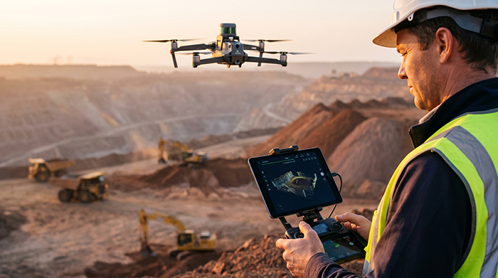
Modern mining operations demand inventory accuracy that traditional surveying methods simply cannot deliver at production speed. Picture an open-pit copper mine running three shifts. By the time a ground survey crew finishes measuring stockpile volumes — walking GPS receivers across unstable aggregate, dodging haul trucks, and processing data back at the office — the numbers […]

Scan-to-BIM automation for industrial LiDAR sensor applications

Drone LiDAR: The Key to Accurate Digital Twin Infrastructure

Smart infrastructure can’t be built on flat maps — it demands geometric truth at centimeter precision. The gap between a conventional aerial photograph and a genuine digital twin isn’t a matter of resolution; it’s a matter of dimension. Where imagery captures surfaces as pixels, LiDAR captures them as measured geometry — every wall angle, every […]

uav lidar mapping for drone LiDAR sensor applications

UAV LiDAR Mapping: The Best Way to Survey Complex Topography

Rugged terrain doesn’t just challenge traditional surveying methods — it defeats them entirely, exposing critical failure points that no amount of field experience or equipment investment can overcome. Line-of-sight limitations are the most immediate constraint for ground crews. Total Stations and conventional GPS-based workflows require unobstructed sightlines between instrument and target. On steep mountain corridors, […]

uav lidar tracking for drone LiDAR sensor applications

Why Lightweight Solid-State LiDAR Increases UAV Flight Time

Payload weight is one of the most consequential variables in multi-rotor UAV design — and the engineering community has the data to prove it. Every 100 grams of additional payload can reduce flight time by 2% to 5% depending on battery capacity and rotor configuration, according to Drone-OSS. That figure compounds quickly when you consider […]

ppk drone mapping for drone LiDAR sensor applications

Industrial Drone LiDAR vs. Consumer Sensors: Why Accuracy Matters

When evaluating ppk drone mapping, it’s important to understand the key differences. A rangefinder measures distance. A mapping-grade UAV LiDAR system captures a georeferenced, three-dimensional model of the world — and that distinction determines whether your data is usable or not. Consumer drone sensors are largely engineered for obstacle avoidance and flight safety, not rigorous […]

catenary curve modeling for 3D LiDAR sensor applications

Drone LiDAR for Power Line Inspection: Why Precision Matters

Passive imaging fails power line inspection at the most fundamental level — it depends entirely on contrast, and a 5mm conductor against a gray sky offers almost none. Photogrammetry reconstructs 3D geometry by matching visual features across overlapping photographs. That process works reasonably well for broad, textured surfaces. It breaks down completely when the target […]

multi-return lidar forestry for 3D LiDAR sensor applications

Why Multi-Return LiDAR is Essential for Accurate Forest DEMs

Multi-return LiDAR forestry applications depend on a deceptively simple principle: a single laser pulse can produce multiple distinct echoes as it travels through a forest canopy. The laser doesn’t pass through leaves — it passes through the gaps between them. As the NOAA Office for Coastal Management explains, “the ability of LiDAR to ‘see through’ […]

lidar vs photogrammetry for 3D LiDAR sensor applications

LiDAR vs. Photogrammetry: Choosing the Best for Terrain Mapping

Two fundamentally different technologies power modern terrain mapping — and understanding that gap is the fastest way to see why the lidar vs photogrammetry debate isn’t really a debate at all for dense environments. LiDAR is an active sensor. It fires its own laser pulses toward the ground and measures the time each pulse takes […]

cleaning robot LiDAR alternatives for robotics LiDAR sensor applications

Solid-State LiDAR: Reducing BOM Costs for Cleaning Robots

Commercial cleaning robotics has crossed a threshold: the market no longer rewards innovation points on a spec sheet — it rewards margin discipline at scale. The US commercial cleaning robots market is maturing fast, and with that maturity comes brutal pressure on hardware costs. Facility managers and fleet operators aren’t buying one robot — they’re […]

port automation AGV LiDAR for robotics LiDAR sensor applications

Why Standard LiDAR Fails on Port AGVs: Marine-Grade Solutions

Port automation AGV LiDAR systems are operating in one of the most punishing industrial environments on earth — yet most are built to standards that assume a factory floor. The shift from manual to automated horizontal transport has reshaped modern port logistics. Where dockworkers once guided straddle carriers and terminal tractors by hand, automated guided […]

Product Enquiry